 Show Posts Show Posts
|
|
Pages: [1]
|
|
1
|
Forums / Classifieds / Re: FS: Integral Bivvy - right zipper, size regular, like new
|
on: January 24, 2015, 04:59:24 PM
|
|
This is the original version of the south col. It uses "tegraltex" fabric. Tegraltex is a trilaminate...outer layer is ripstop nylon, membrane is PTFE similar to Gore, and the inner layer is "Nexus" which is a non-woven fiber backing that absorbs and wicks water/vapor).
It's a year round all purpose bivy. Right side zippered access with Velcro backup. Full Tegraltex top and foot section. Sheltered horizontal face level opening with zippered closure and zippered layer of no-see-um netting for better venting in foul weather. 22" side zipper makes entry easier, Velcroed weather flaps are great for venting. A replaceable wire stiffener in the hood brim encourages air flow and keeps fabric off your face.
Length: 92" (fits to 6ft 6")
Width: 32" at shoulders tapering to 22" at foot Girth: 69" at shoulders tapering to 55" at foot
Weight: 1.9 lbs (870g)
Packed Size: 15" long x 5"
|
|
|
|
|
3
|
Forums / Classifieds / SOLD: Integral Bivvy - right zipper, size regular, like new
|
on: January 19, 2015, 07:43:38 PM
|
Breathable membrane, seam sealed, 4-season bivvy. "South Col" model. Has insect screen, zipper hood and integrated pole/stay to create a peak around user's face area. Size "regular" with a right hand zip. Roomy to hold a regular camp pad and sleeping bag. It weighs approximately 600 grams. Packs super small. Made in Canada 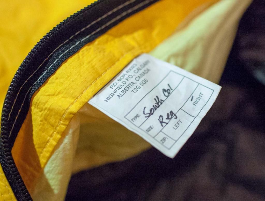 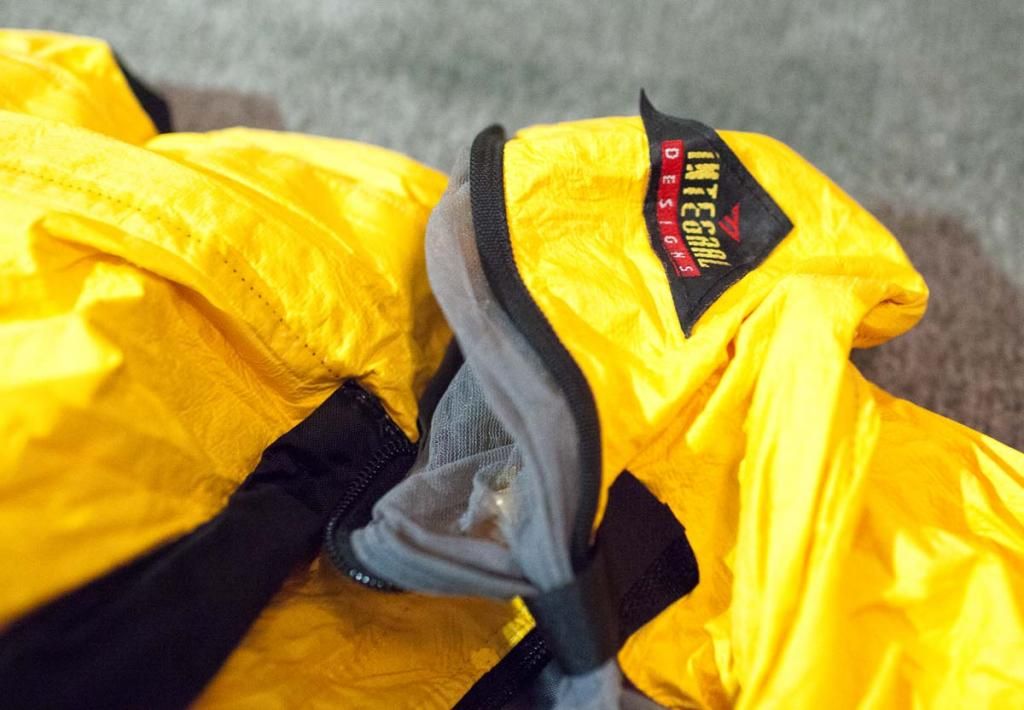 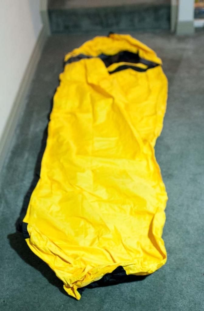 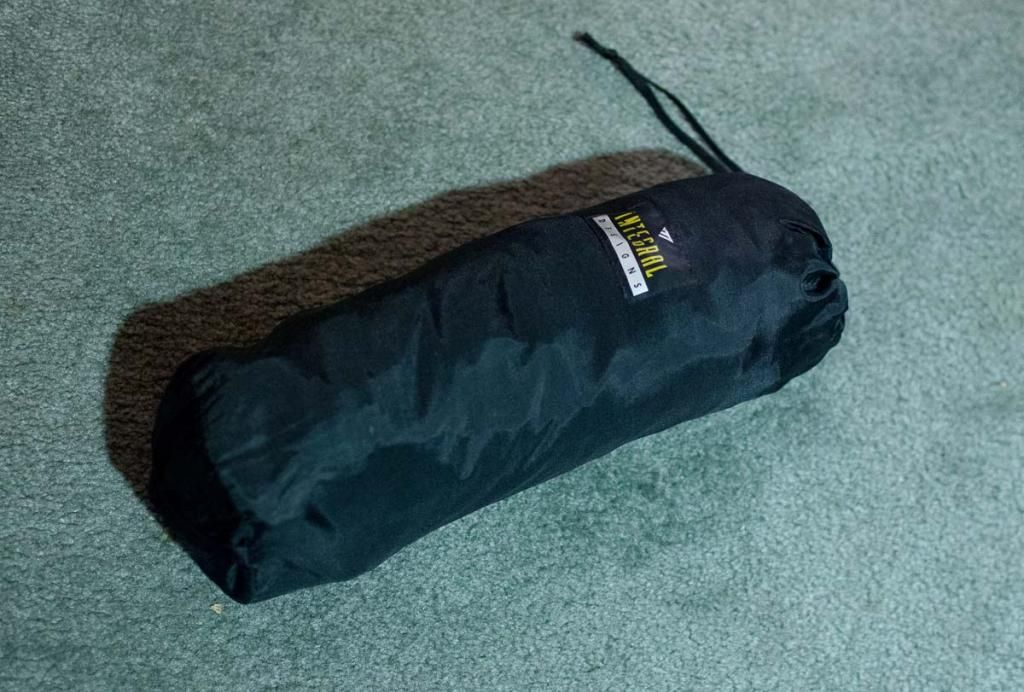 |
|
|
|
|
5
|
Forums / Bikepacking / GPS maps - a recommendation
|
on: July 16, 2012, 04:51:10 PM
|
A great, fairly comprehensive resource for GPS mapping is the "Ontario Trails Project" http://trailmaps.torontogeocaching.com/The trails are not well-described at all, but it's a decent source for finding out some of the basic locations of things and seeing how things can be connected. It won't tell you if the route is good for biking or which directions are the most fun, or what to expect in terms of the terrain. That will take additional resources...but you will find there's a lot of info out on the web in blog, photo and website formats...if you initially know what trail names to search for, you can start to find the extra details elsewhere. By the way, some of the bike trail systems as shown within the OTP map set are horribly incomplete. Last I looked at network-y trail systems like Hilton, Copeland, Mansfield, Durham...the map barely shows 1/10th of the trails. But in terms of bike-packing, a lot of the long-distance routes are very well covered, eg. The Bruce, Grand River, Trans-Canada, Ganaraska, Oak Ridges and so on. Everything I've personally ridden has checked out pretty much entirely. The maps are highly complete and accurate. |
|
|
|
|
6
|
Forums / Bikepacking / Re: Any Canadians out there??
|
on: August 07, 2011, 05:20:29 PM
|
Just thought I would share a few route ideas. My tastes run towards techy single track, so be aware that these routes are all contain fairly difficult riding for loaded bikes. All of these routes are loops, and can be started and finished at any place around the route. 1. Guelph -> Guelph loop ( via Brantford - Hamilton - Hilton Falls ). Some road, Cambridge Rail Trail, Grand Valley Trail, Hamilton - Brantford Rail Trail, Dundas Trail system, Waterdown -> Hilton via Bruce Trail thru Mt. Nemo, Kelso, Hilton Falls, Limehouse, Guelph Radial Trail. This is a huge loop...like 250km, half being really rocky trail with lots of hike-a-bike. I have ridden all of it, and it's really challenging. Never did it all together....yet. 2. Guelph -> Guelph loop ( via Limehouse - Caledon) Guelph Radial Trail, Bruce Trail, Rail-trail, singletrack, rail,trail, road. It's a 1-night. About 200km. 3. Beaver Valley -> Kolapore -> 3-Stage -> Blue -> Loree Forest -> Beaver Valley Almost continuous singletrack, huge amounts of climbing. 1-overnight. Probably 150KM with over 10,000' of climbing. Sweet trail. As a further brainstorm, there are several long-distance trails that look interesting. One in particular that has intrigued me for a couple of years is this: 4. Wilderness section of the Ganaraska Trail, return loop via road: http://ganaraskawilderness.wetpaint.com/Big question mark on this one. It's wet (beaver dams) and about 60km through the wilderness, with a return by road. The most remote and committed of the options here. Chance of bears. Also, these links may inspire someone: http://www.oakridgestrail.org/http://www.ganaraska-hiking-trail.ca/I have copious amounts of mapping and tons of experience on most areas on these routes, so please let me know if I should elaborate on the route details. |
|
|
|
|
7
|
Forums / Bikepacking / Re: Any Canadians out there??
|
on: July 14, 2011, 07:29:05 AM
|
Wondering if there are any fellow Canadians or peeps in Canada out there beyond the computer screen??
I'm in Guelph, southern Ontario right now. Hey BazB! I'm also in Southern Ontario (Hamilton). I guess we're pretty close to one another. I have been doing / working on a few new ideas for local Ontario routes. Can you PM me? |
|
|
|
|
8
|
Forums / Routes / Re: Victorian (Australia) Trails
|
on: January 04, 2010, 07:20:28 AM
|
So it seems that there is conflict between Stevage and Lukey for the dates. Does anyone else want to throw their name into the mix as a tie breaker.
Sigh! Isn't that the way? Stevage and I have opposite problems. He's leaving for Tas, I'll be just arriving from doing the Tasmanian Trail. If you ultimately decide to go with the 30-31 weekend, please keep me in the loop. There's a 50/50 chance I could be there, just can't commit 100% -- all very contingent on the travel during the week leading into that weekend. But I can definitely try for it. I should be able to let you know 100% a few days ahead of time, hopefully. I will shoot you my contact details in a PM. |
|
|
|
|
9
|
Forums / Routes / Re: Victorian (Australia) Trails
|
on: January 03, 2010, 04:28:37 PM
|
|
Hey...I'm still interested! For me, there dates that work are Jan 6-7. (In fact any time between Jan 2 and Jan 7 would work for me.) Otways or Dandenongs would be amazing, I'm happy with anything you want to plan out as far as the route goes. No worries about the singlespeed...I will be sightseeing myself, not looking for a fast pace, just a good time.
|
|
|
|
|
10
|
Forums / Routes / Re: Tasmanian Trail
|
on: December 22, 2009, 08:17:24 PM
|
Hey Mate, currently in Tassie until early February(wife is having a baby).
Flick me an email if ya keen to meet up for a ride
Hey Benny, I'm sending an email. Would be great to connect. (Congrats on the kid! What bike will s/he ride?) |
|
|
|
|
11
|
Forums / Routes / Re: Tasmanian Trail
|
on: December 17, 2009, 11:14:29 PM
|
It's close-ish...
I know exactly what you mean...I just spent a bunch of hours poring over all the route maps. The mapbook is an encrypted PDF. It wasn't straightforward to produce an isolated map graphic for each map page within the book. But I managed to rip the maps out...somehow.  Put all these maps into Topofusion as a user map overlay and began the laborious process of stitching the pages together and tracing the route. Good exercise to have gone through! I can already tell there's definitely a few funny/vague things within the maps. For one obvious thing, the scale legend on the pages always shows as the same exact scale on each page, but these maps are at totally different levels of magnification. What a complete joke! Some pages show 4 times the actual area of others. The scale is dramatically different, but the legend makes it seem as if each map shows a terrain slice that is consistently the same size. In fact, if you were looking for a turn based on mileage and the image of the map according to the scale, you couldn't get in the ballpark. As I worked on the fitment of the map pages to my geometrically correct background topo map, it quickly become obvious that many of the maps have been stretched or distorted so that they "fill the printable area of the page", regardless of the actual shape that the terrain would be. So the actual "shape" of the route is only relative, not absolute in any sense. For another thing, the background topo maps for Tasmania already show the track in many places. It was a bit unsettling to see that the route within the book was way too general and inaccurate in a lot of places. For example, there was one area where the aerial photo shows that the route is along a zig-zagged switchbacked road which is criss-crossed with other zig-zagging criss-crossing roads. In this web of connections, the book simply shows a line cutting straight across in a totally impossible manner. Checking that against the aerial photo and it's apparent that you would have to fork first one way, pass a couple of roads, and then take another specific next fork back the other way. Out of perhaps 8 possible road entrances in this small area, only one specific combination of turns would lead to the right road, and unintuitively, you would have to double back in order to line up with the correct trail. Not covered in the route book directions or shown on the map. I would have to hope there are a lot of blazes? Anyhow, thank goodness for Topofusion! It's a really helpful sanity check on the guidebook at this point... |
|
|
|
|
12
|
Forums / Routes / Re: Victorian (Australia) Trails
|
on: December 17, 2009, 10:05:40 PM
|
Alistair, I will be visiting from Canada. My available dates would be very specific just due to travel, but I would be really interested if we can coordinate the timing! I could arrange: Jan 11&12 Feb 2 - Feb 7 |
|
|
|
|
13
|
Forums / Routes / Re: Tasmanian Trail
|
on: December 12, 2009, 03:38:43 PM
|
Note also that the guidebook is written as if travelling from Devonport to Dover, meaning that those travelling from Dover to Devonport will have to decipher the directions and distances.
So I have received the latest edition of the book. On the left margin is a mileage/distance column from North to South, and the middle has a route description/points-of-interest/notes/GPS-coords and the right margin has a mileage/distance column South to North. If you are traveling north, the turns and directions read backwards but the distances will work either way, depending on which column you refer to. I gather this is a major improvement. The book is quite comprehensive. It's basically like a huge cue-sheet. It has every imaginable bit of info I think might come in handy. For example, it gives directions for alternate routes, shopping, special notes on the terrain for bikes...all kinds of stuff. I'll let everyone know about the accuracy in a couple of months... |
|
|
|
|
14
|
Forums / Routes / Re: Tasmanian Trail
|
on: December 12, 2009, 05:08:19 AM
|
OK, I have received an email back from Peter. The new Trail Guidebook will be available next week, and it will be a PDF download with two years of updates for about $15AUD, payable online. This is an ideal arrangement! No worries about running out of printed copies, and I don't have to deal with shipping or figure out a bookshop who I can order it from etc. I noticed this morning that the site has been changed to reflect this. http://www.tasmaniantrail.com.au/Pages/Guidebook.html |
|
|
|
|
15
|
Forums / Routes / Re: Tasmanian Trail
|
on: December 11, 2009, 05:18:53 PM
|
Your best bet for obtaining a copy of the guidebook is to email peter_fehre at yahoo.com.au
I'd be happy to answer any questions about the parts of the trail that I've covered (Dover to Bracknell) if you post them up.
Thanks for this tip. I've emailed Peter and hope this will be sorted out. The whole trip is kind of a big unknown. I just can't get much of a feel for what I'll be finding along the way. I guess that is partly appealing, actually. Right now, I have little information about camping, water, food supplies and other services available along the route. Will I need to be fully self-supported, or can I count on simply finding stuff and resupplying along the way? I have decided to ride in the direction of the guide book now, for various reasons. Is there anything special you think I ought to know in particular? Thanks! |
|
|
|
|
16
|
Forums / Routes / Re: Tasmanian Trail
|
on: November 03, 2009, 05:30:56 AM
|
I've been reading all the trip reports I can find! Thanks for pointing out this link. It has been hard to have a detailed idea of what the route is like on a day-by-day and mile-by-mile basis. I've been almost 100% limited to the information I can discover online. Campsite options and services along the route have been a bit hard to discover. Unfortunately, the guide book is currently out of print. I contacted a 1/2 dozen bookstores in and around Tasmania hoping to find a copy on a shelf without any luck. This site has also been pretty useful: http://tastrail.wikispaces.com/(You're not the same Stevage are you?) Many links to other trip reports can be found there. Unless something changes and I can locate the guidebook, I have a feeling this is shaping up to be quite a navigational adventure... My only choice is traveling in the Dover > Devonport direction. My timing will be around Jan 14 - Jan 21. |
|
|
|
|
17
|
Forums / Routes / Re: Tasmanian Trail
|
on: September 01, 2009, 08:52:01 PM
|
I'd recommend ordering it if you don't already have it. It seems pretty good and may answer some of your questions.
Ahh...good point. I've been meaning to order it, but hadn't yet gotten around to it. I think I'll put that on my high priority list. Thanks for the reminder. I'll post up here again for sure once I have a report.  |
|
|
|
|
18
|
Forums / Routes / Tasmanian Trail
|
on: August 30, 2009, 10:14:02 PM
|
|
Currently residing in Canada, but I have an upcoming family reunion in Tasmania in January 2010. While I'm there, I'm planning a ride of the Tasmanian Trail. Perfect time to do it...the airport is near one end of the trail and the reunion is near the other. Too convenient!
Anybody on here who is planning on being on the trail in January?
Is there anyone who has experience with the ride? I have a few questions...
|
|
|
|
|
19
|
Forums / Bikepacking / Re: Bears - how often and how to deal with?
|
on: July 01, 2009, 06:26:07 PM
|
One charged a friend of mine and did a fast 180 when the others came around the bend.
I lived in Fernie BC for three years and while I saw some steaming piles, I never saw a griz, and just a few black bears.
I lived in Jasper Alberta for a couple of years. Lots of bears up there. My neighbour there was mauled by a Grizzly on a solo mountain bike ride. He lived, but it was a pretty close call. He was a very big, strong guy, and the mauling happened within 1km from the town hospital. Fluke encounter, apparently he actually struck the bear on singletrack right near the golf course - not a normal place to see a Griz. Every three or four years someone is attacked or killed somewhere. It seems to me that it's usually someone moving fast and quiet. I think there is at least some danger for off-road riders. A google search for "bear cyclist" turns up a number of events reported in the media. However, bad encounters are very very rare. No need to be hysterical, but why take chances? While I was living in Jasper I personally had weekly bear encounters while biking. Most sightings were black bears, and most of the bears were already running away from me by the time I spotted them, although a couple of them presented bigger problems. My advice is to always take a bear bell (or two) to hang on your bike while moving in bear country, and when in treed areas or places with limited sightlines, to yell and make noise when "overrunning" the bell noise on fast downhills, near loud rivers, or when coming around blind corners (especially if the blind corner is where there are rocks or cliffs which block sound). Camping/food handling advice above is spot on. I was also told that if you come across remnants of a freshly killed animal (hair / hide / bones etc.) you want to get far away. Sometimes a bear will hang around and scavenge/defend these areas. I found that the bikers in the Jasper area would exchange info about fresh animal kills in an effort to avoid these trails (and avoid bears). Rather more lightheartedly, I also knew a woman whose bike was attacked while she was off the bike and it was parked somewhere. A black bear essentially ate the saddle. It had this big "shark bite" missing from it. This happened, of course, in front of a crowd of tourists at a popular gift shop. Those lucky people had a terrific story when they got home. But blech! I would never want to eat a saddle.  |
|
|
|
|
20
|
Forums / Bikepacking / Re: Introduction Thread
|
on: July 01, 2009, 06:02:35 PM
|
|
Hi, I'm Luke, and I live in Hamilton Ontario Canada. I did my first bikepacking trips about 10-12 years ago. After a long hiatus, I'm getting back into things during the past year. Really enjoying this site!
I just finished a 5 day trip and I have plans for a couple of other excursions to come.
|
|
|
|
|


