 Topic Name: Pacific Northwest Trail Topic Name: Pacific Northwest Trail
|
on: December 11, 2014, 11:13:16 AM
|
ScottM
bikepacking.net admin
Location: Wherever my rig is parked.
Posts: 2864


|
 |
« on: December 11, 2014, 11:13:16 AM » |
|
 The PNT seems to be another newcomer to the National Scenic Trails world (designated in 2009) that has received very little attention from bikepackers. Does anyone know of attempts to ride or explore it, bikepack-style? I see some locals chiming in with some knowledge on this thread: http://www.bikepacking.net/forum/index.php?topic=2878.0The PNT appears to be the same as the AZT in that it's open to bikes outside Wilderness and National Parks. This is *good* news for the case of bikes on National Scenic Trails (a battleground is the CDT right now, and specifically the new section to-be-constructed in the Cochetopa Hills). A couple of the Wilderness areas look like major issues, but I'm not sure they are enough to kill the idea of a thru-ride connecting the CDT to the coast. Just wondering if anyone out there is keen on the trail or has more info. The thread linked above talks a lot about a Washington-only bikepack route that was dreamed up but never happened, so I figured a new thread on the PNT was warranted. |
|
|
|
« Last Edit: April 19, 2015, 05:23:23 PM by ScottM »
|
 Logged
|
|
|
|
 Topic Name: Pacific Northwest Trail Topic Name: Pacific Northwest Trail
|
Reply #1 on: December 11, 2014, 08:26:00 PM
|
threepin
Location: whitefish mt
Posts: 156

|
 |
« Reply #1 on: December 11, 2014, 08:26:00 PM » |
|
in NW mt i have looked at the maps and read the descriptions. Looks like a ton of vert, some of it seeming to be pointless i believe parts are still just a route without tread. I think Casey might have some insights. The portion from Glacier to Eureka/Roosville may be a problem long term as there is likely to be a recommendation for a new wilderness there, probably with the road corridor Grave creek trail creek continuing but much of the rest off limits.
|
|
|
|
|
 Logged
|
|
|
|
 Topic Name: Pacific Northwest Trail Topic Name: Pacific Northwest Trail
|
Reply #2 on: December 12, 2014, 09:01:02 PM
|
chrisx
Location: Portland
Posts: 407

|
 |
« Reply #2 on: December 12, 2014, 09:01:02 PM » |
|
Basically you are looking at Ross lake, WA and east. The Pasayten Wilderness can be bypassed on dirt roads. From Ross lake West there is no easy bypass, and multiple wilderness and National parks. Perhaps South to Twisp WA, and the Methow Valley where trails exist. Then a 10 mile hard carry, to Stehekin, WA. Then a Ferry ride on lake Chelan, and a flag stop and trails and forest roads to Leavenworth, WA. Whidbey Island is a road ride. No real reason to rejoin the PNT West of Ross lake Plenty of places to ride your bike though. San Juan Islands. Olympic Peninsula. The Olympic Discovery Trail, a work in progress, is open to bikes in its entity, even if it crosses into Olympic National Park. The PNT in closed to bikes in ONP. The PNT is open to bikes by order of the United States Congress. Only an order from them can change that. Most trails are closed to bikes, because of horse riders doing a lot of bellowing. Bike riders remain silent to many times. And get kicked of trails because of their silence. The PNT is open to bikes because someone asked the correct person to make it that way. The Congress followed the recommendation of the person in charge of the Department of the Interior, to the letter. Lobby for bikes it works ONP boundary 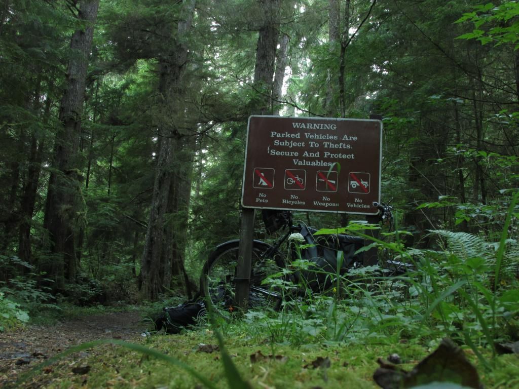 The fog is on the inside of the camera lens  bring your rain gear on the PNT the beach walk is my favorite part 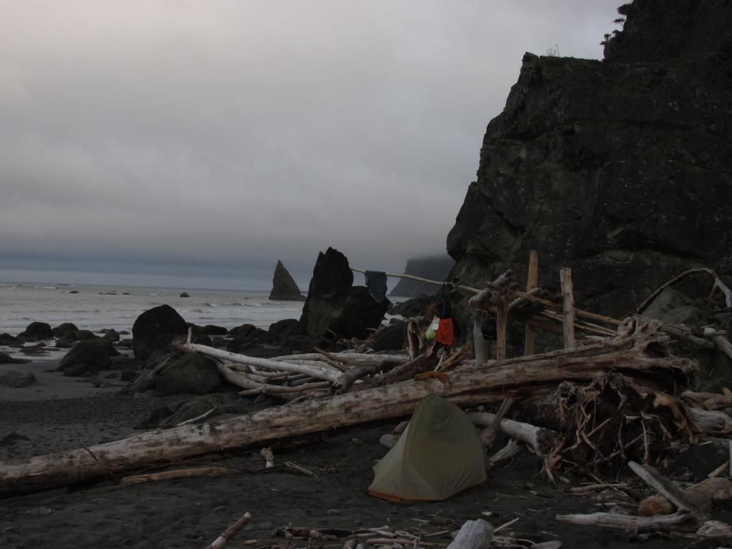 recommend a tent, because of brown spiders 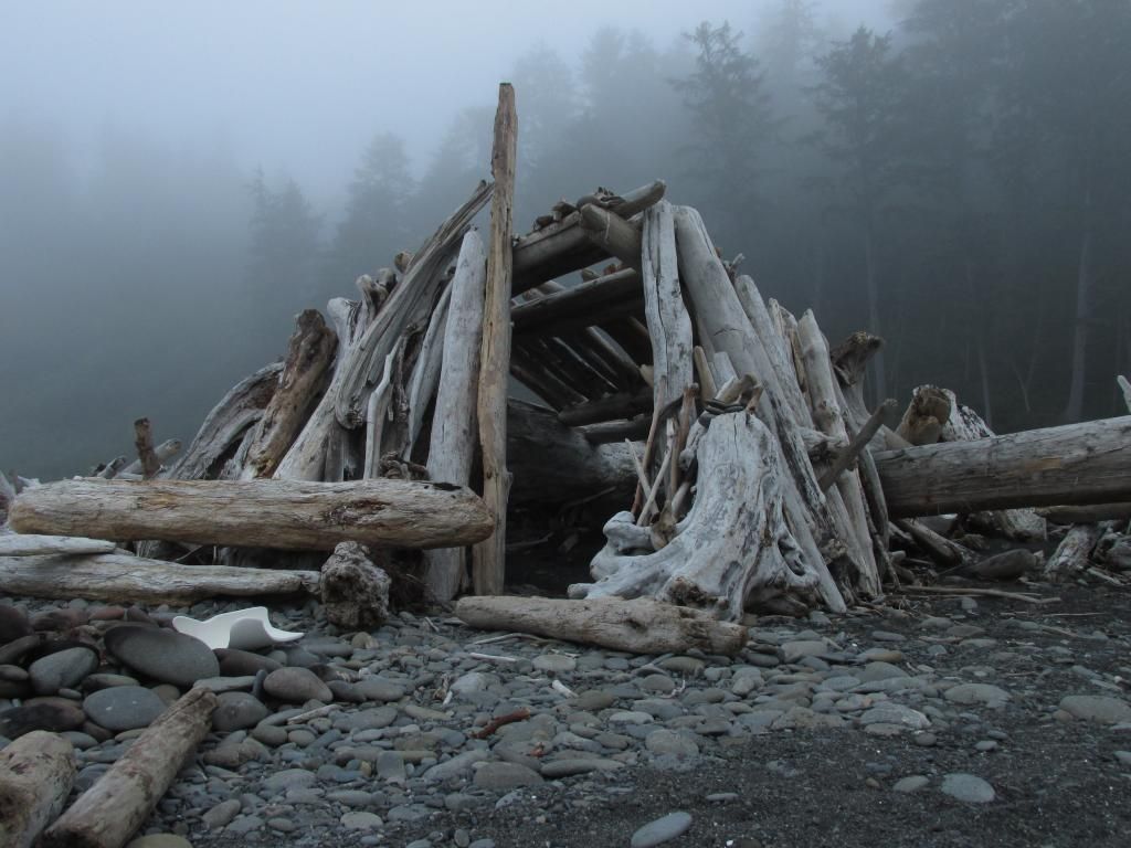 I bought a $40 bicycle to stash in the woods 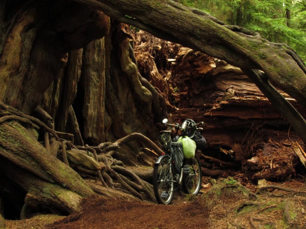 while hiking the PNT where it is closed to bikes  - 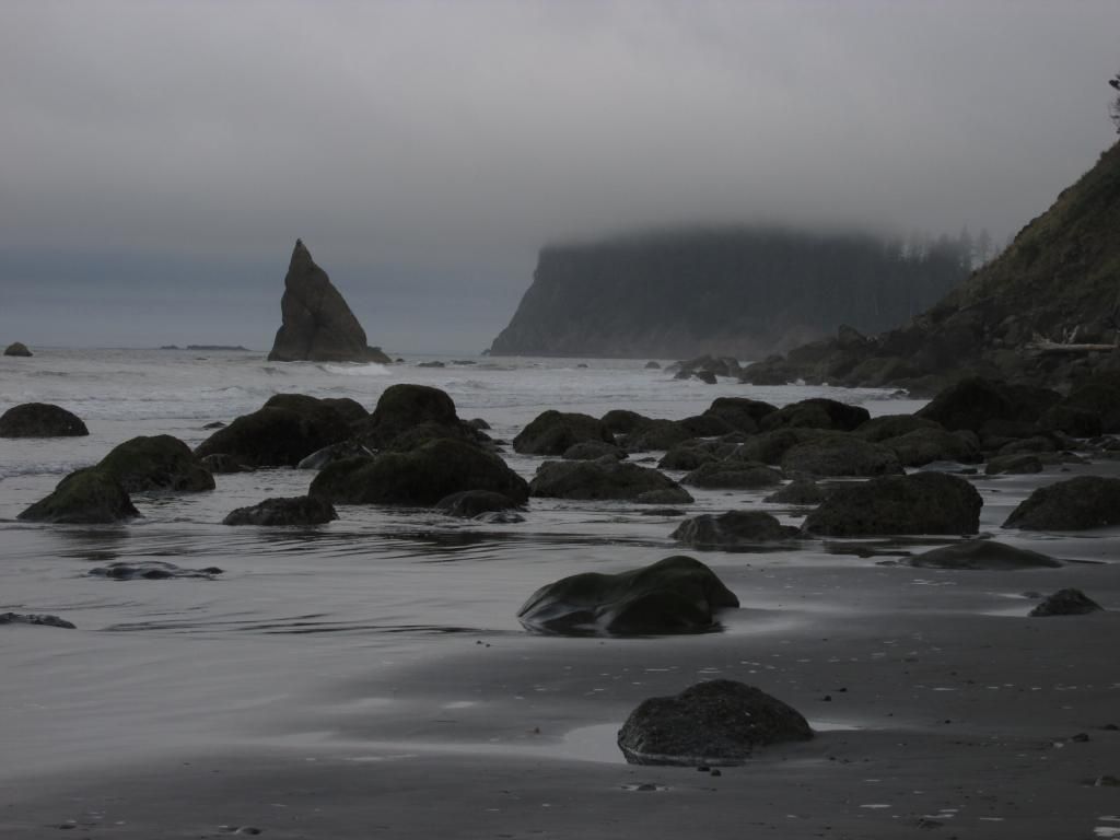 |
|
|
|
« Last Edit: December 12, 2014, 09:39:26 PM by chrisx »
|
 Logged
|
|
|
|
 Topic Name: Pacific Northwest Trail Topic Name: Pacific Northwest Trail
|
Reply #3 on: December 13, 2014, 09:55:48 AM
|
ScottM
bikepacking.net admin
Location: Wherever my rig is parked.
Posts: 2864


|
 |
« Reply #3 on: December 13, 2014, 09:55:48 AM » |
|
The PNT is open to bikes by order of the United States Congress. Only an order from them can change that. Most trails are closed to bikes, because of horse riders doing a lot of bellowing. Bike riders remain silent to many times. And get kicked of trails because of their silence.
The PNT is open to bikes because someone asked the correct person to make it that way. The Congress followed the recommendation of the person in charge of the Department of the Interior, to the letter.
Lobby for bikes it works
Agreed on bike riders remaining silent and lobbying working. Thanks for the info on the PNT. Do you have any sense of who it was that cared about this long distance trails, enough to keep it open to bikes? There seems to not be much interest or info on riding it -- especially bikepacking it. Looks like you have done a fair bit (maybe all or most of it?). There's no info on the PNT's official website about bikes or bike routes. A couple people in the thread I linked mentioned emailing them about it and getting no response. Has anyone put together a full bike route, or thru-ridden it, that you know of? Thanks! |
|
|
|
|
 Logged
|
|
|
|
 Topic Name: Pacific Northwest Trail Topic Name: Pacific Northwest Trail
|
Reply #4 on: December 13, 2014, 09:56:24 AM
|
ScottM
bikepacking.net admin
Location: Wherever my rig is parked.
Posts: 2864


|
 |
« Reply #4 on: December 13, 2014, 09:56:24 AM » |
|
Great pics, BTW. I really like the idea of a long PNW singletrack tour of some kind.
|
|
|
|
|
 Logged
|
|
|
|
 Topic Name: Pacific Northwest Trail Topic Name: Pacific Northwest Trail
|
Reply #5 on: December 13, 2014, 01:05:05 PM
|
chrisx
Location: Portland
Posts: 407

|
 |
« Reply #5 on: December 13, 2014, 01:05:05 PM » |
|
Pacific Northwest Trail Digest by Tim Youngbluth http://www.amazon.it/Pacific-Northwest-Trail-Digest-Edition-ebook/dp/B00C326M6EThe 2015 updated edition will be out around March. Written by a retired Colonel with military precision. Or, go to the PNT forum and buy it direct from the author, (Bravo on the forum). $14? I don't have the maps with me. There is a dirt road from West Glacier MT traveling NW to the PNT. There are multiple dirt roads traveling SW around the Pasayten Wilderness to Ross lake and hwy 20. In 2013 I told some forest rangers in Stehekin, WA, about the guys carrying bikes across the Grand Canyon on their backs. After thinking about that for a couple of days, they like the idea. Don't cheat the line! I have seen maybe 25% of the PNT. I probably should not admit this. Last July I washed my train ticket to West Glacier. Amtrak would not replace it, I did not go. 2015? Do you have any sense of who it was that cared about this long distance trails, enough to keep it open to bikes?I do know who planed to ride their bike on the PNT 10 years in advance Very important to talk to the correct person about these things |
|
|
|
|
 Logged
|
|
|
|
 Topic Name: Pacific Northwest Trail Topic Name: Pacific Northwest Trail
|
Reply #6 on: December 13, 2014, 04:33:07 PM
|
AZTtripper
Moderator
Location: Tucson, AZ
Posts: 1732

|
 |
« Reply #6 on: December 13, 2014, 04:33:07 PM » |
|
In 2013 I told some forest rangers in Stehekin, WA, about the guys carrying bikes across the Grand Canyon on their backs. After thinking about that for a couple of days, they like the idea.
In 06 I carried thru the wilderness portion of the Temporal Gulch Passage, I gave myself the excuse of needing a preview of my Canyon carrying system. I have told several rangers that I did it. Not sure if they care or they are just impressed or they just think I am crazy. None have given me any grief about it. It would be cool if you could get a waiver to carry only, not ride. But unless it's a really busy trail like the Canyon I doubt they could/would trust everyone not to ride.
Not that I would encourage anyone to break the law, I've done this carry twice and the first time I didn't know it actually says not to posses rather then just not to ride. In 04 a guy on horseback said he thought they should give bikes the AZT even in Wilderness for those who are thru riding. To be honest now that I know more about the other non bike passages, I doubt we would want to use them anyway. The amount of HAB would be ridiculous.
Parts of this trail look incredible might it make more sense to try to figure out a way to use parts of it to make a couple of good loops? It looks like a full trip may involve major detours. Also a couple of 250 loops might make for a more user friendly concept. Just my .02
|
|
|
|
|
 Logged
|
|
|
|
 Topic Name: Pacific Northwest Trail Topic Name: Pacific Northwest Trail
|
Reply #7 on: December 13, 2014, 06:45:53 PM
|
chrisx
Location: Portland
Posts: 407

|
 |
« Reply #7 on: December 13, 2014, 06:45:53 PM » |
|
The biggest detour, (western Washington), could be handled by going into Canada. The kettle valley railway trail into Vancouver perhaps.
|
|
|
|
|
 Logged
|
|
|
|
 Topic Name: Pacific Northwest Trail Topic Name: Pacific Northwest Trail
|
Reply #8 on: December 14, 2014, 06:01:40 PM
|
chrisx
Location: Portland
Posts: 407

|
 |
« Reply #8 on: December 14, 2014, 06:01:40 PM » |
|
Not that I would encourage anyone to break the law, I've done this carry twice and the first time I didn't know it actually says not to posses rather then just not to ride. ç anyway. The amount of HAB would be ridiculous.
Parts of this trail look incredible might it make more sense to try to figure out a way to use parts of it to make a couple of good loops? It looks like a full trip may involve major detours. Also a couple of 250 loops might make for a more user friendly concept. Just my .02
The fed interprets laws differently in different places. In Florida they confiscated my tomato entering the country. In California they allow tomatoes into the country. This was 3 days apart. In Washington, they said using a machine in the wilderness is against the law. Possessing a machine is not against the law. They said using my front wheel as a walking stick could be illeagle. Northern Washington is a good place to be in July and August. A week or 2 into September expect, well, winter to begin. In June winter snow is still blocking passes. There are some very remote areas up there. And it takes effort to get in and out of the area. https://www.youtube.com/watch?v=Cr00FBpNqSQLoops sound good. But. http://www.wilderness.net/map.cfm?xmin=-13885188.4162&ymin=5707429.4217&xmax=-13015378.2846&ymax=6274849.7374pedaling your bike to the loop could be a 250 loop in it self. How about the PNT, to the Idaho Centennial Trail, and back to Seattle on the rail trails of the old Milwaukee railway. Because of all the wilderness, there are few choices. A couple of years ago I went electricity free in North Cascade National Park for a few weeks. The Olympic Peninsula is a good destination as well. |
|
|
|
|
 Logged
|
|
|
|
 Topic Name: Pacific Northwest Trail Topic Name: Pacific Northwest Trail
|
Reply #9 on: December 14, 2014, 07:35:35 PM
|
|
 Topic Name: Pacific Northwest Trail Topic Name: Pacific Northwest Trail
|
Reply #10 on: December 14, 2014, 09:39:58 PM
|
chrisx
Location: Portland
Posts: 407

|
 |
« Reply #10 on: December 14, 2014, 09:39:58 PM » |
|
|
|
|
|
|
 Logged
|
|
|
|
 Topic Name: Pacific Northwest Trail Topic Name: Pacific Northwest Trail
|
Reply #11 on: December 15, 2014, 11:24:06 AM
|
bsavery
Posts: 17

|
 |
« Reply #11 on: December 15, 2014, 11:24:06 AM » |
|
Basically you are looking at Ross lake, WA and east. The Pasayten Wilderness can be bypassed on dirt roads. From Ross lake West there is no easy bypass, and multiple wilderness and National parks. Perhaps South to Twisp WA, and the Methow Valley where trails exist. Then a 10 mile hard carry, to Stehekin, WA. Then a Ferry ride on lake Chelan, and a flag stop and trails and forest roads to Leavenworth, WA.
If you're doing that, why not ride all the way down to snoqualmie corridor and ride the trails back there? |
|
|
|
|
 Logged
|
|
|
|
 Topic Name: Pacific Northwest Trail Topic Name: Pacific Northwest Trail
|
Reply #12 on: January 07, 2015, 04:33:24 PM
|
MattL
Location: Sunnyvale, CA
Posts: 97

|
 |
« Reply #12 on: January 07, 2015, 04:33:24 PM » |
|
I can't speak to the whole route, but some of that is wilderness. I have backpacked the Lost Coast Trail in the Sinkyone Wilderness, and it is my all-time favorite backpacking trip. |
|
|
|
|
 Logged
|
I finished the 2013 TD. I did the whole damn thing,
excluding the 2013 detours, in good style and—as
far as I know—totally in accordance with the rules.
|
|
|
 Topic Name: Pacific Northwest Trail Topic Name: Pacific Northwest Trail
|
Reply #13 on: January 17, 2015, 03:20:14 PM
|
HappyWanderer
Posts: 37

|
 |
« Reply #13 on: January 17, 2015, 03:20:14 PM » |
|
I was looking last summer at doing the north Idaho section. From what I can determine by looking at maps and talking to a couple of locals there really not a trail around lion's head ridge east of Priest lake. And it is quite remote. Not even a hiking trail. It is more a line drawn on a map. You may be able to do it, but might have to carry the bike out of necessity and bushwack. We never made the trip ourselves. Wondering if anyone has more information on this section.
|
|
|
|
|
 Logged
|
|
|
|
 Topic Name: Pacific Northwest Trail Topic Name: Pacific Northwest Trail
|
Reply #14 on: January 17, 2015, 04:02:51 PM
|
chrisx
Location: Portland
Posts: 407

|
 |
« Reply #14 on: January 17, 2015, 04:02:51 PM » |
|
I can't speak to the whole route, but some of that is wilderness. I have backpacked the Lost Coast Trail in the Sinkyone Wilderness, and it is my all-time favorite backpacking trip.
California state wilderness does not show up on the link http://www.wilderness.net/map.cfm?xmin=-13885188.4162&ymin=5707429.4217&xmax=-13015378.2846&ymax=6274849.7374Plenty of roads into there, or so it appears on the map. Do you have any bike routes between Redwoods National and State Parks, or out to Kings Range National Conservation Area? I was looking last summer at doing the north Idaho section. From what I can determine by looking at maps and talking to a couple of locals there really not a trail around lion's head ridge east of Priest lake. And it is quite remote. Not even a hiking trail. It is more a line drawn on a map. You may be able to do it, but might have to carry the bike out of necessity and bushwack. We never made the trip ourselves. Wondering if anyone has more information on this section.
This is a young trail. Any room for a shovel on your bike? https://www.youtube.com/watch?v=ntt3wy-L8Ok |
|
|
|
|
 Logged
|
|
|
|
 Topic Name: Pacific Northwest Trail Topic Name: Pacific Northwest Trail
|
Reply #15 on: January 17, 2015, 04:18:35 PM
|
chrisx
Location: Portland
Posts: 407

|
 |
« Reply #15 on: January 17, 2015, 04:18:35 PM » |
|
|
|
|
|
|
 Logged
|
|
|
|
 Topic Name: Pacific Northwest Trail Topic Name: Pacific Northwest Trail
|
Reply #16 on: January 17, 2015, 07:45:29 PM
|
chrisx
Location: Portland
Posts: 407

|
 |
« Reply #16 on: January 17, 2015, 07:45:29 PM » |
|
|
|
|
|
|
 Logged
|
|
|
|
 Topic Name: Pacific Northwest Trail Topic Name: Pacific Northwest Trail
|
Reply #17 on: January 20, 2015, 05:47:16 PM
|
HappyWanderer
Posts: 37

|
 |
« Reply #17 on: January 20, 2015, 05:47:16 PM » |
|
chrisx,
Thanks for the info! I might just carry a shovel up there next summer. Sounds like fun. I have family in the area I might be able to rope into helping as well!
|
|
|
|
|
 Logged
|
|
|
|
 Topic Name: Pacific Northwest Trail Topic Name: Pacific Northwest Trail
|
Reply #18 on: January 25, 2015, 06:12:16 AM
|
willapajames
Location: Stowe, Vermont
Posts: 20


|
 |
« Reply #18 on: January 25, 2015, 06:12:16 AM » |
|
Shame you have to bypass the Pasayten Wilderness. I've hiked in there a bit, and it's unbelievably gorgeous. Plus I've got some family history up there, so it's a special place to me. My dad was on trail crews up there as a young man, and I've heard stories my whole life about those days... blowing up stumps with dynamite, packing in supplies with horses or having them air-dropped, fighting fires... all sorts of manly shit.
|
|
|
|
|
 Logged
|
"All men dream: but not equally. Those who dream by night in the dusty recesses of their minds wake in the day to find that it was vanity: but the dreamers of the day are dangerous men, for they may act their dreams with open eyes, to make it possible." - T.E. Lawrence
|
|
|
 Topic Name: Pacific Northwest Trail Topic Name: Pacific Northwest Trail
|
Reply #19 on: January 25, 2015, 07:58:03 PM
|
HappyWanderer
Posts: 37

|
 |
« Reply #19 on: January 25, 2015, 07:58:03 PM » |
|
I e-mailed the PNT organization to look into the N. Idaho section and see about volunteering. Looks like cyclists need to be more active in volunteering and advocating for bikes on this route. Maybe we can find some more volunteers who are interested here on the forum... I will post the response: "The PNT is not known as a mountain biking trail, although there are sections where Mountain Bikes are permitted. It’s pretty much up to the landowner as to whether they are permitted or not. Some short segments, that are on rail grades, are open to road bikes; probably less than 5%. The trail is mainly a hiking trail and equestrian wherever possible. We would love to have you as a volunteer and maybe form a volunteer group in your area. The PNTA can assist with some trail tools! We’re are not sure at this point where the Trail corridor is going to be from the Kootenai to Priest Lake, as the Idaho Panhandle NF is still trying to come up with a route they can agree to. We’ll be starting the Advisory committee meetings this spring and hope to have the route determined within the next two years. Feel free to call me, or email me any questions! Thanks, Jon Knechtel Jon Knechtel Director of Trail Operations Board Member-Partnership for National Trails Pacific Northwest Trail Association 24854 Charles Jones Memorial Circle #4 Sedro-Woolley, WA 98284 Office: (360) 854-9415 Fax: (360) 854-7665 Cell: (360) 391-0788 The mission of the PNTA is to promote, protect, and maintain the Pacific Northwest National Scenic Trail in a manner that make a lasting contribution to the recreation, education, and enjoyment of present and future generations. Happy Trails and Keep on Hiking! The PNTA needs your support, vist us at www.pnt.org and find out how you can help!" |
|
|
|
|
 Logged
|
|
|
|
|
|