 Topic Name: 2011 AZTR and 300 planning thread Topic Name: 2011 AZTR and 300 planning thread
|
Reply #80 on: February 28, 2011, 04:14:54 AM
|
AZTtripper
Moderator
Location: Tucson, AZ
Posts: 1732

|
 |
« Reply #80 on: February 28, 2011, 04:14:54 AM » |
|
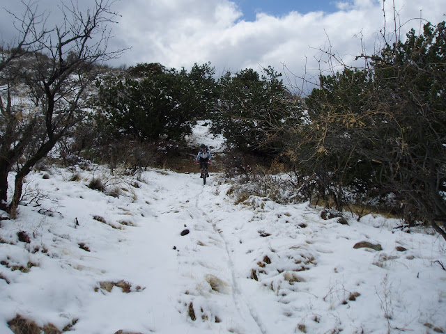
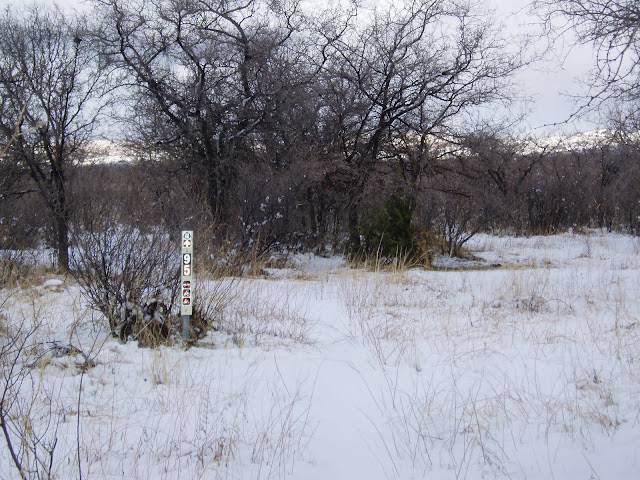
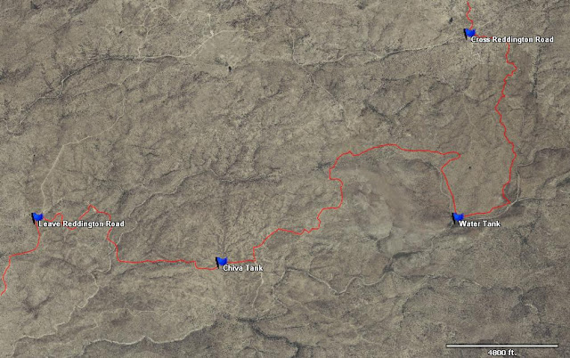
Nice pics Marshall that looks like a lot of snow hopefully its mostly just the piles from the plows. No way of knowing how fast it might all melt off. The other issue up there will be if things dry out as well. A lot of the stuff North of Blue Ridge Ranger Station is that sticky gumbo mud that is not good to ride when wet. It does dry quick but if it's just rained or the snow has only just melted off it's possible that some sections will still have to be detoured. Technically no one has yet to ride a full AZT trip picking up all of the Single Track in one go. Scott and I have both ridden all of the course trails but not all on the same trip. And then of course there's the El Oso to Sunflower (Roosevelt Lake area) with the Mazatzals and dropping into Rye that we have both done but won't be included until next year, hopefully. For now we even had snow in the Reddington area yesterday.  Max aka Adrenalin Junkie and I had a great day cutting fresh tracks in the snow. Great thing down here is the decomposed granite of our trails is very rideable if not even better when wet.  Start of some sweet snow covered ST.  We also found another water source out that way. Shortly before the start of the ST right where we go past a corral and thru a gate there is a big tank just off course. Could be a good reliable source that would allow leaving Tucson super light. It's only about 16 miles from the BLM office so most of the faster riders wouldn't likely bother, but I found last year that by going light whenever possible it really helped. The Water Tank is only about 100 feet off course.  |
|
|
|
« Last Edit: February 28, 2011, 04:30:48 AM by AZTtripper »
|
 Logged
|
|
|
|
 Topic Name: 2011 AZTR and 300 planning thread Topic Name: 2011 AZTR and 300 planning thread
|
Reply #81 on: February 28, 2011, 07:30:39 AM
|
Marshal
Location: Colorado
Posts: 951


|
 |
« Reply #81 on: February 28, 2011, 07:30:39 AM » |
|
It had just snowed the night before (I 17 & I 40 was closed at Flag) But I would say the typically depth was about 1.5-2 feet with alot of it new wet snow from the last storm.
Ha, If I make it all the way to Mormon lake in some ways I will be hoping for enough snow to force me onto some pave.
|
|
|
|
|
 Logged
|
|
|
|
 Topic Name: 2011 AZTR and 300 planning thread Topic Name: 2011 AZTR and 300 planning thread
|
Reply #82 on: February 28, 2011, 07:49:55 AM
|
ScottM
bikepacking.net admin
Location: Wherever my rig is parked.
Posts: 2864


|
 |
« Reply #82 on: February 28, 2011, 07:49:55 AM » |
|
Love the bike snowman pic! All that snow you rode in yesterday will be melted in about five seconds, I'd say, given how sunny it is this AM.
That's a bit of snow by Mormon Lake. We'll see how the next month+ pans out. Could be more snow, could be lots of sunny and windy days. There probably won't be a call about the snow detours until 1-2 weeks before the race, I would guess.
Tim, we should plan to get out to ride Cmo Doretea -> Hope Camp -> Cmo Loma Alta.
|
|
|
|
|
 Logged
|
|
|
|
 Topic Name: 2011 AZTR and 300 planning thread Topic Name: 2011 AZTR and 300 planning thread
|
Reply #83 on: February 28, 2011, 07:59:09 AM
|
AZTtripper
Moderator
Location: Tucson, AZ
Posts: 1732

|
 |
« Reply #83 on: February 28, 2011, 07:59:09 AM » |
|
Love the bike snowman pic! All that snow you rode in yesterday will be melted in about five seconds, I'd say, given how sunny it is this AM.
That's a bit of snow by Mormon Lake. We'll see how the next month+ pans out. Could be more snow, could be lots of sunny and windy days. There probably won't be a call about the snow detours until 1-2 weeks before the race, I would guess.
Tim, we should plan to get out to ride Cmo Doretea -> Hope Camp -> Cmo Loma Alta.
Yeah the snow was both falling and melting while we were riding it was fun though. When I got to Jacob Lake in April 06 there was still a lot of snow but one of the resort workers said it would likely be summer in about 2 weeks. "We don't really have a spring" she said "one day there's snow on the ground the next day it's hot and the snow is gone" gotta love AZ. Will the park people let us ride that old two track from Hope Camp I thought it was signed no bikes. I did see tracks though. I went out that way with the Crazies I mentioned the tracks to the ranger he didn't seem happy with the neighborhood peeps using that trail. They also walk dogs on it also a no no "they think because they live over here they can do as they please" was his take on it. That could be a nice addition though. |
|
|
|
|
 Logged
|
|
|
|
 Topic Name: 2011 AZTR and 300 planning thread Topic Name: 2011 AZTR and 300 planning thread
|
Reply #84 on: February 28, 2011, 07:53:21 PM
|
ScottM
bikepacking.net admin
Location: Wherever my rig is parked.
Posts: 2864


|
 |
« Reply #84 on: February 28, 2011, 07:53:21 PM » |
|
I just heard today that access won't be ready for the Hope Camp 2-track, so route will stay the same (X9 road) as last year there.
Tiny new piece of singletrack north of Freeman Road to tie in, and then I am assured that we will be on all singletrack instead of the dirt road out out by Fagan Lake. It will be nice to not have to ride that "construction path" in the middle of the night too.
The only other outstanding route issue (for the 300) I have is the diversion dam by Box Cyn. I am not sure if they are still working on the dam, but I am guessing they are. Will check before I go Gila River Rambling and perhaps check it out in person too.
|
|
|
|
|
 Logged
|
|
|
|
 Topic Name: 2011 AZTR and 300 planning thread Topic Name: 2011 AZTR and 300 planning thread
|
Reply #85 on: March 01, 2011, 04:50:02 AM
|
AZTtripper
Moderator
Location: Tucson, AZ
Posts: 1732

|
 |
« Reply #85 on: March 01, 2011, 04:50:02 AM » |
|
So whats up at the river do we need to drive out there we can use the truck if need be.
Other then the new ST by Freeman sounds like the course should be the same as last year.
Max and I did the Swizzle ST over to Chiva and then over to the corrals that way. This felt easier then staying on the road. I know we talked about it but can't remember why we didn't go that way.
|
|
|
|
|
 Logged
|
|
|
|
 Topic Name: 2011 AZTR and 300 planning thread Topic Name: 2011 AZTR and 300 planning thread
|
Reply #86 on: March 01, 2011, 01:29:08 PM
|
ScottM
bikepacking.net admin
Location: Wherever my rig is parked.
Posts: 2864


|
 |
« Reply #86 on: March 01, 2011, 01:29:08 PM » |
|
Oh, you went through the gate that says no vehicles then up the wash / old ATV trail? That way is more direct and perhaps more fun, but as far as I know the part between the gates is closed to bikes.
New ST by the lakes road too.
The dam is being reconstructed and they are taking up a lot of room with equipment in the area and I believe the diversion dam itself was completely locked/blocked last time Chad/Max were there. I haven't been able to find any timeline info about it online, so will have to make some calls and perhaps go recon. My thought is that the locals have figured out a way to get around/across with their ATVs. Or maybe they are done.
Worst case we'd have to do Ripsey and White Cyn. (!!) Or if the river stays low (by the gage they have been keeping it lower it seems, though certainly not shut off) we could ford it.
|
|
|
|
|
 Logged
|
|
|
|
 Topic Name: 2011 AZTR and 300 planning thread Topic Name: 2011 AZTR and 300 planning thread
|
Reply #87 on: March 01, 2011, 02:06:04 PM
|
AZTtripper
Moderator
Location: Tucson, AZ
Posts: 1732

|
 |
« Reply #87 on: March 01, 2011, 02:06:04 PM » |
|
Or we could ride Ripsey and then cross on the highway bridge and ride the road into Superior and finish on the LOST to Picket Post for the easiest 300 ever, one and only. 750 riders will continue on from Hewett Station. Isn't there new ST along the south side of the river.
I could see adding this as an option for the blue route of the AZT in general.
Or and here's where my dead brain cells finally clicked in a very duh moment. The Dam is under construction the river is turned off period. You could make the ford by the ranch and somehow make your way to Picket Post.
|
|
|
|
|
 Logged
|
|
|
|
 Topic Name: 2011 AZTR and 300 planning thread Topic Name: 2011 AZTR and 300 planning thread
|
Reply #88 on: March 09, 2011, 01:54:28 PM
|
YuriB
Posts: 63


|
 |
« Reply #88 on: March 09, 2011, 01:54:28 PM » |
|
Thanks for the water chart Tim!
|
|
|
|
|
 Logged
|
|
|
|
 Topic Name: 2011 AZTR and 300 planning thread Topic Name: 2011 AZTR and 300 planning thread
|
Reply #89 on: March 11, 2011, 10:01:50 AM
|
ScottM
bikepacking.net admin
Location: Wherever my rig is parked.
Posts: 2864


|
 |
« Reply #89 on: March 11, 2011, 10:01:50 AM » |
|
Important Route NoteJust a heads up for those dialing in the route and studying maps: as alluded to earlier in this thread, the diversion dam that we usually use to cross (most of) the Gila River is closed for construction... until the end of 2011. I am hoping to hear of and/or do some on the ground recon to see if is is possible to get through. But I am not too hopeful that anything workable can be found, so I would say we need to start planning for a different way to cross. This might mean that the Ripsey portion of the AZT will be part of the route (cheers!  applause!), and that we cross the river on the car bridge in Kelvin. The question then becomes what the route does from there. The AZT is unfinished for the next ~15 miles. My goal is to keep the route as close to the same effort level and moving time between each year, so I will have to give it some thought and analysis in TopoFusion. Stay tuned...
|
|
|
|
|
 Logged
|
|
|
|
 Topic Name: 2011 AZTR and 300 planning thread Topic Name: 2011 AZTR and 300 planning thread
|
Reply #90 on: March 13, 2011, 04:41:08 AM
|
AZTtripper
Moderator
Location: Tucson, AZ
Posts: 1732

|
 |
« Reply #90 on: March 13, 2011, 04:41:08 AM » |
|
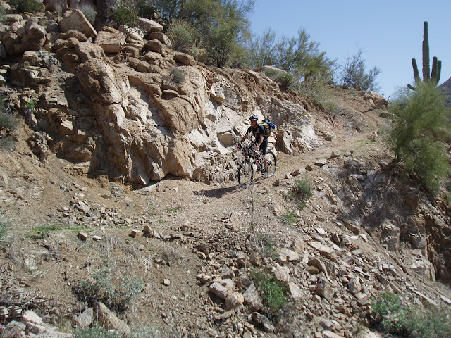
Kinda sucks about the diversion dam but then again I think we are coming up with an even better route. Don't worry Marshall it won't be a harder better route if anything there's more water access on the new route and possibly less HAB.  Plus some of the sweetest new single track I have ridden in a while. After riding in this area last week Max and I were so happy with the trails and the overall beauty of the area that we are going back for more.  Some of the sweet stuff.  Stellar views for those who get there in the daylight.  And one of the extra water sources if we go this way.  |
|
|
|
|
 Logged
|
|
|
|
 Topic Name: 2011 AZTR and 300 planning thread Topic Name: 2011 AZTR and 300 planning thread
|
Reply #91 on: March 14, 2011, 10:28:49 AM
|
OurManInTheNorth
Location: Helsinki, Finland
Posts: 101

|
 |
« Reply #91 on: March 14, 2011, 10:28:49 AM » |
|
Hey Jackson - noticed you mentioned the possibility of a fall ITT of the AZT300 route - what time of year are you planning? I'm over at the beginning of Nov for a conference, considering an ITT sometime before that i.e. last couple of weeks in Oct. Also hoping to do a s-n GC crossing (sans bike, with wife, though hopefully not strapped to my rucksack!). I think the water options are going to be way worse than normal, and especially compared to last year when pretty much all of the creeks etc still had some water in them. I think the 'camel' strategy you and I (and Krefs from the sounds of it) had of carrying lots of water most of the time will be called for...
Not coming this year for the race, will definitely be Spot observing and tying it in with last years memories...
Ian
|
|
|
|
|
 Logged
|
|
|
|
 Topic Name: 2011 AZTR and 300 planning thread Topic Name: 2011 AZTR and 300 planning thread
|
Reply #92 on: March 14, 2011, 03:27:31 PM
|
jimfab
Are those new slacks?
Location: Buckeye, AZ
Posts: 107


|
 |
« Reply #92 on: March 14, 2011, 03:27:31 PM » |
|
Question for those that know lemon...
I am trying to put my gear together for the 300. If weather is like it has ben the past few days here in Arizona, what can you expect on top of Lemon and other higher elevations? i have never been on Lemon. I am going to try and ride the Lemon - Oracle section before the start to get a better idea. Looking at clothing, sleeping options.
Thanks- JF
|
|
|
|
|
 Logged
|
|
|
|
 Topic Name: 2011 AZTR and 300 planning thread Topic Name: 2011 AZTR and 300 planning thread
|
Reply #93 on: March 15, 2011, 01:59:31 AM
|
AZTtripper
Moderator
Location: Tucson, AZ
Posts: 1732

|
 |
« Reply #93 on: March 15, 2011, 01:59:31 AM » |
|
Hey Jackson - noticed you mentioned the possibility of a fall ITT of the AZT300 route - what time of year are you planning? I'm over at the beginning of Nov for a conference, considering an ITT sometime before that i.e. last couple of weeks in Oct. Also hoping to do a s-n GC crossing (sans bike, with wife, though hopefully not strapped to my rucksack!). I think the water options are going to be way worse than normal, and especially compared to last year when pretty much all of the creeks etc still had some water in them. I think the 'camel' strategy you and I (and Krefs from the sounds of it) had of carrying lots of water most of the time will be called for...
Not coming this year for the race, will definitely be Spot observing and tying it in with last years memories...
Ian
Ian the last couple of weeks in Oct can still be pretty warm down south perfect time of year to ride from Payson North though. Also check out all of the water sources posted a couple of pages back even with out creeks there are lots of places to refill if you want to. Also some of the possible changes will put even more water on course. |
|
|
|
|
 Logged
|
|
|
|
 Topic Name: 2011 AZTR and 300 planning thread Topic Name: 2011 AZTR and 300 planning thread
|
Reply #94 on: March 15, 2011, 02:08:38 AM
|
AZTtripper
Moderator
Location: Tucson, AZ
Posts: 1732

|
 |
« Reply #94 on: March 15, 2011, 02:08:38 AM » |
|
Question for those that know lemon...
I am trying to put my gear together for the 300. If weather is like it has ben the past few days here in Arizona, what can you expect on top of Lemon and other higher elevations? i have never been on Lemon. I am going to try and ride the Lemon - Oracle section before the start to get a better idea. Looking at clothing, sleeping options.
Thanks- JF
JF snows melting up there should easily be clear by race time but there might still be some up at the top still. Even with all of the snow last year including the day of the start Oracle Ridge was still clear by race day. As for clothing and sleeping, just depends on how high up the mountain you want to go at night. |
|
|
|
|
 Logged
|
|
|
|
 Topic Name: 2011 AZTR and 300 planning thread Topic Name: 2011 AZTR and 300 planning thread
|
Reply #95 on: March 17, 2011, 10:33:03 PM
|
OurManInTheNorth
Location: Helsinki, Finland
Posts: 101

|
 |
« Reply #95 on: March 17, 2011, 10:33:03 PM » |
|
AZT, thanks for the info, do you think the 2nd, 3rd or 4th week in Nov would be better weatherwise? And how warm is pretty warm, I overheated badly on the second day of the AZT this year (and had massive sleep deprivation then nearly got hypothermia in the evening, the last few days getting to the startline at the Mexican border took their toll I think!)...
|
|
|
|
|
 Logged
|
|
|
|
 Topic Name: 2011 AZTR and 300 planning thread Topic Name: 2011 AZTR and 300 planning thread
|
Reply #96 on: March 18, 2011, 04:51:47 AM
|
AZTtripper
Moderator
Location: Tucson, AZ
Posts: 1732

|
 |
« Reply #96 on: March 18, 2011, 04:51:47 AM » |
|
Based on last year most of October was still in the 90's then by mid November days were nice and we had one little cold snap lows in the 40's.
I guessing the cold won't bother you as much as the heat. Anything is possible of course but typically we don't have any snow up on Lemon until December.
Tim
|
|
|
|
|
 Logged
|
|
|
|
 Topic Name: 2011 AZTR and 300 planning thread Topic Name: 2011 AZTR and 300 planning thread
|
Reply #97 on: March 18, 2011, 05:57:48 AM
|
OurManInTheNorth
Location: Helsinki, Finland
Posts: 101

|
 |
« Reply #97 on: March 18, 2011, 05:57:48 AM » |
|
Yeah I appreciated the snow from Mexico to halfway to Patagonia at the start, that's what I'd been training in all winter and having left Flagstaff in the snow to arrive at the start, had packed accordingly :-) Mid Nov sounds pretty good, will look into an ITT then.
Ian
|
|
|
|
|
 Logged
|
|
|
|
 Topic Name: 2011 AZTR and 300 planning thread Topic Name: 2011 AZTR and 300 planning thread
|
Reply #98 on: March 18, 2011, 12:37:29 PM
|
ScottM
bikepacking.net admin
Location: Wherever my rig is parked.
Posts: 2864


|
 |
« Reply #98 on: March 18, 2011, 12:37:29 PM » |
|
Hey all, The sign up sheet for SPOT tracking is online here: https://spreadsheets.google.com/viewform?hl=en&formkey=dGpKdkxvaXZ6aDB1eWFYT29JU3Bsd1E6MA#gid=0This is not race registration! There is no registration. You only need to fill out this form if you want to be on the tracker, either with your own SPOT or with one rented from us (trackleaders.com). There are options for both on the form. $30 is the rental fee, and we are asking a $10 fee for tracking if you have your own SPOT. This tracking stuff is getting to be a lot of work, and we are having to justify all the time spent. Thanks. Paypal link is on this page: http://trackleaders.com/supportStay tuned for a determination on the route to bypass the dam (mentioned above). Should be exciting to include some new trail. |
|
|
|
|
 Logged
|
|
|
|
 Topic Name: 2011 AZTR and 300 planning thread Topic Name: 2011 AZTR and 300 planning thread
|
Reply #99 on: March 19, 2011, 11:37:31 AM
|
Endurance Junkie
Location: Tucson,AZ
Posts: 79

|
 |
« Reply #99 on: March 19, 2011, 11:37:31 AM » |
|
All signed up for the FMD, less than 30 days away , should be a grand adventure!
|
|
|
|
|
 Logged
|
Finding myself by way of bike
|
|
|
|
|