 Topic Name: 2011 AZTR and 300 planning thread Topic Name: 2011 AZTR and 300 planning thread
|
Reply #100 on: March 26, 2011, 08:00:42 AM
|
AZTtripper
Moderator
Location: Tucson, AZ
Posts: 1732

|
 |
« Reply #100 on: March 26, 2011, 08:00:42 AM » |
|
Won't be long now. The final piece of new trail south of Tucson should be finished today. Scott and I have been hashing out the options now that the diversion dam is closed. He should have a final route to post up as soon as we get a track for the new piece. After that I will redo the water table to match what ever route he comes up with.
Tim
|
|
|
|
|
 Logged
|
|
|
|
 Topic Name: 2011 AZTR and 300 planning thread Topic Name: 2011 AZTR and 300 planning thread
|
Reply #101 on: April 05, 2011, 10:34:46 AM
|
ScottM
bikepacking.net admin
Location: Wherever the GeoPro is parked.
Posts: 2863


|
 |
« Reply #101 on: April 05, 2011, 10:34:46 AM » |
|
Without further ado, I give you the AZT 300 route for 2011: http://www.topofusion.com/azt/gpx/AZT-300-2011-rev1.gpxQuite a few changes from last year. - In Patagonia, we now turn right, not left, taking HWY 82 to the town of Sonoita, then rejoining the AZT much earlier than in previous years. More miles of AZT on this "east side" Santa Rita route, and some very sweet sections such as the "flume" trail. This route is at least 3-4 hours faster than the "west side" route.
- Two new pieces of singletrack in the Cienega / Colinas segments of the AZT. One saves a not-so-fun steep construction path hike, the other avoids a fence crossing, going under HWY 83 in a culvert.
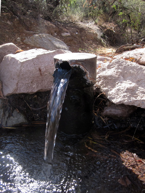
- The big one: after finishing up the Boulder Segment, north of Antelope Peak, we now stick with the AZT, all the way through the Ripsey segment, on some new singletrack down to a car bridge crossing of the Gila River. This section is very sweet and seriously ups the singletrack factor on the race. After the Gila Bridge we'll climb HWY 177 for a few miles, then use a brutal series of 4WD roads to reconnect with the old AZT 300 route in Box Canyon. This change seriously backloads the course with some difficult terrain (and also some absurdly scenic terrain). Be ready for it. One bonus about this route is the artesian well, which is just slightly off route, which provides a much needed water source to the last 50 miles of the route.
The "east side" Santa Rita route is being made to compensate for the increased difficulty in the latter half of the race. Moving time between 2010 and 2011 routes should be comparable. The bonus is that the "east side" route actually has more AZT miles. Amazingly, total mileage and elevation change are within a mile and within 1000' of each other, from 2010/2011. Due to the last minute nature of the change (only last weekend did we complete recon and determine that the old route is truly no longer viable), I have provided a waypoint file detailing some of the turns and water sources/services on the new sections of the 2011 route. Study hard. http://www.topofusion.com/azt/gpx/AZT-300-2011-waypoints-rev1.gpxI have not finished the cues. Hope to have them completed by the end of the week. For now the 2010 cues are still on the site. Full AZT - The full AZT will use the same route as the AZT 300, and I have published a new AZTR file on the race site as well. The 2010 snow detours file is still in the GPX directory, but it looks like we will not need to use all of them. At this time it's looking like only the North Rim AZT and perhaps the singletrack around the Peaks in Flagstaff will need to be skipped. Everything in the Mormon Mtn/Mogollon Rim section should be good to go, I am hoping. Stay tuned for an update on that as the race gets closer. Thanks for the patience with the changes everyone. I was hoping to figure something out so we could continue to use the old route, but I am actually quite excited about the changes. I think it will make for a better route, overall. Tracking infoHere is the link to sign up for a trackleaders rental, or to have your own private SPOT added to the AZTR tracker: https://spreadsheets.google.com/viewform?hl=en&formkey=dGpKdkxvaXZ6aDB1eWFYT29JU3Bsd1E6MA#gid=0This is not race registration! There is no registration (though if you are coming and not being tracked, you can email me to let me know, but it is not required). You only need to fill out this form if you want to be on the tracker, either with your own SPOT or with one rented from trackleaders.com. There are options for both on the form. $30 is the rental fee, and $10 is the fee for tracking if you have your own SPOT and want to be on the group map. You are also responsible for getting the rental SPOT back to us, and need to provide 2AA lithium batteries to power the unit during the race. To pay by paypal: http://trackleaders.com/supportIf you are renting a unit, I will have them at the 300 start line (but not the AZTR start), or you can pick SPOTs up early from me in Tucson. Just get in touch. |
|
|
|
« Last Edit: April 05, 2011, 10:41:26 AM by ScottM »
|
 Logged
|
|
|
|
 Topic Name: 2011 AZTR and 300 planning thread Topic Name: 2011 AZTR and 300 planning thread
|
Reply #102 on: April 05, 2011, 10:50:00 AM
|
ScottM
bikepacking.net admin
Location: Wherever the GeoPro is parked.
Posts: 2863


|
 |
« Reply #102 on: April 05, 2011, 10:50:00 AM » |
|
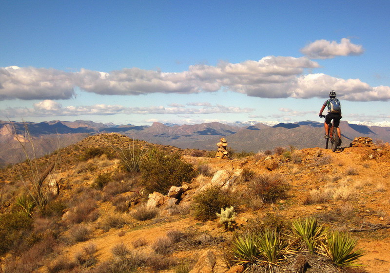
A few pics of the new stuff. Grassland singletrack on the east side of the Santa Ritas:

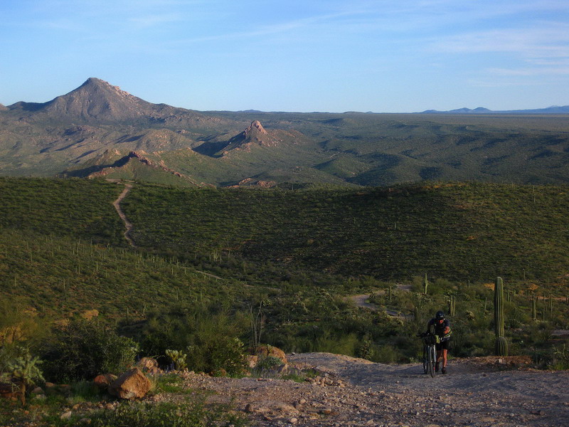
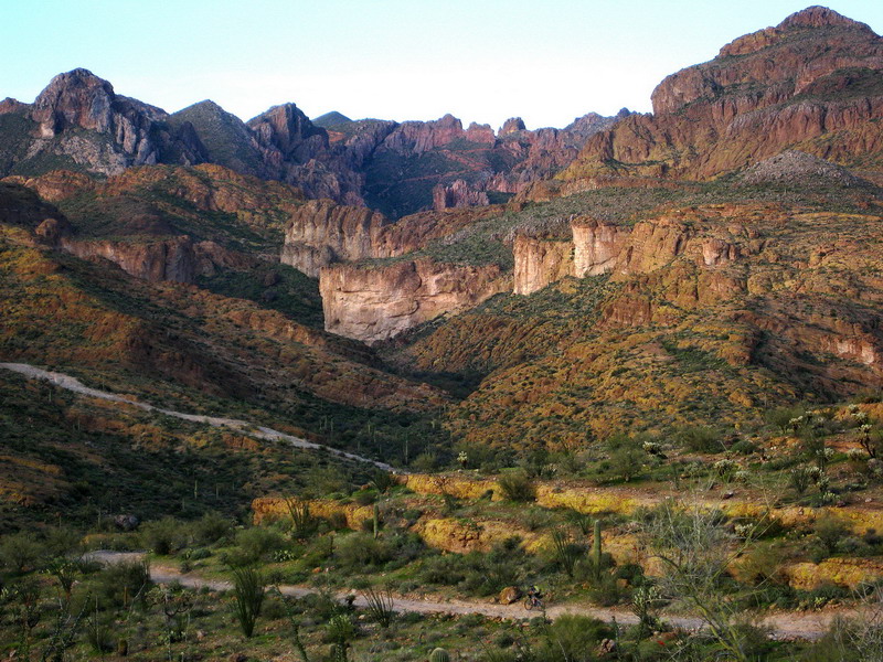
Ripsey!!!  Here's the artesian well, now on route:  Solid rock roads and brutal rollers:  Martinez Canyon:  It's going to be an awesome year. Can't wait for the party to get started. |
|
|
|
|
 Logged
|
|
|
|
 Topic Name: 2011 AZTR and 300 planning thread Topic Name: 2011 AZTR and 300 planning thread
|
Reply #103 on: April 05, 2011, 10:58:22 AM
|
maadjurguer
Sandbagger
Location: N33.51103 W111.66533
Posts: 20


|
 |
« Reply #103 on: April 05, 2011, 10:58:22 AM » |
|
Thanks for your hard work and stoke pictures on this race.....alas, I am not doing it this year. I was on track to be ready and then life threw me a monkey wrench with the last 6 weeks seeing me off my bike a lot.....not cool! To all those who are rockin this....I will live vicariously through you all as you grind your way north.
|
|
|
|
|
 Logged
|
|
|
|
 Topic Name: 2011 AZTR and 300 planning thread Topic Name: 2011 AZTR and 300 planning thread
|
Reply #104 on: April 05, 2011, 11:11:48 AM
|
YuriB
Posts: 63


|
 |
« Reply #104 on: April 05, 2011, 11:11:48 AM » |
|
East side of the Santa Ritas! Woooohooo!
|
|
|
|
|
 Logged
|
|
|
|
 Topic Name: 2011 AZTR and 300 planning thread Topic Name: 2011 AZTR and 300 planning thread
|
Reply #105 on: April 05, 2011, 11:40:29 AM
|
krefs
Location: Prescott, AZ
Posts: 492

|
 |
« Reply #105 on: April 05, 2011, 11:40:29 AM » |
|
I love it...this thing just keeps getting better. And backloading it with brutal jeep roads *before* Box Canyon? That'll cause more than a few riders to question their sanity. What's an estimate on how long it'll take to get from the Gila Crossing to Box Canyon at a modest pace?
|
|
|
|
|
 Logged
|
|
|
|
 Topic Name: 2011 AZTR and 300 planning thread Topic Name: 2011 AZTR and 300 planning thread
|
Reply #106 on: April 05, 2011, 01:00:15 PM
|
krefs
Location: Prescott, AZ
Posts: 492

|
 |
« Reply #106 on: April 05, 2011, 01:00:15 PM » |
|
With these changes, I'm left wondering how late the Rincon Store is open ;-)
|
|
|
|
|
 Logged
|
|
|
|
 Topic Name: 2011 AZTR and 300 planning thread Topic Name: 2011 AZTR and 300 planning thread
|
Reply #107 on: April 05, 2011, 01:31:17 PM
|
ScottM
bikepacking.net admin
Location: Wherever the GeoPro is parked.
Posts: 2863


|
 |
« Reply #107 on: April 05, 2011, 01:31:17 PM » |
|
5-6 hours moving time is a rough estimate for a modest pace on those ~27 miles.
Didn't take you long to realize that fast pace into Tucson hurts resupply options! I don't think Rincon Store is going to work for those pushing into the first night. The upside is that the Mt. Lemmon store should be much easier to reach before it closes on Saturday, and it will give the hammerheads a fighting chance to get onto the cooler slopes of Mt. Lemmon before the day heats up. I think overall the change is advantageous... just save some for Martinez! And make sure to bring extra eyeball glue for when you start bleeding out of them (as always) on Orphan Boy.
|
|
|
|
|
 Logged
|
|
|
|
 Topic Name: 2011 AZTR and 300 planning thread Topic Name: 2011 AZTR and 300 planning thread
|
Reply #108 on: April 05, 2011, 07:28:38 PM
|
Marshal
Location: Colorado
Posts: 951


|
 |
« Reply #108 on: April 05, 2011, 07:28:38 PM » |
|
Never occurred to me Scott might change the beginning, ha- so much for nice night 1 camp spot I had all picked out
And I was wondering how Scott was going to balance out the dam diversion-time&effort, now I knows
Imo it’s going to be tough to backtrack back down to the Gila River & go right back up-ouch, but I really do want to see/use that artesian well!!
|
|
|
|
|
 Logged
|
|
|
|
 Topic Name: 2011 AZTR and 300 planning thread Topic Name: 2011 AZTR and 300 planning thread
|
Reply #109 on: April 05, 2011, 07:30:36 PM
|
Marshal
Location: Colorado
Posts: 951


|
 |
« Reply #109 on: April 05, 2011, 07:30:36 PM » |
|
Oh, and the wife keeps asking how many others are in for the full meal deal?
2?
|
|
|
|
|
 Logged
|
|
|
|
 Topic Name: 2011 AZTR and 300 planning thread Topic Name: 2011 AZTR and 300 planning thread
|
Reply #110 on: April 05, 2011, 07:40:39 PM
|
Endurance Junkie
Location: Tucson,AZ
Posts: 79

|
 |
« Reply #110 on: April 05, 2011, 07:40:39 PM » |
|
Oh, and the wife keeps asking how many others are in for the full meal deal?
2?
Looks like 4 of us I thought? I have a total of 18 days off work, so I know i'm go'n. I'm look'n for a ride to the start if anyone has room? |
|
|
|
|
 Logged
|
Finding myself by way of bike
|
|
|
 Topic Name: 2011 AZTR and 300 planning thread Topic Name: 2011 AZTR and 300 planning thread
|
Reply #111 on: April 05, 2011, 08:33:56 PM
|
Chad B
Moderator
Posts: 484

|
 |
« Reply #111 on: April 05, 2011, 08:33:56 PM » |
|
Hmmmmmm......tempting.
|
|
|
|
|
 Logged
|
|
|
|
 Topic Name: 2011 AZTR and 300 planning thread Topic Name: 2011 AZTR and 300 planning thread
|
Reply #112 on: April 06, 2011, 07:14:29 AM
|
AZTtripper
Moderator
Location: Tucson, AZ
Posts: 1732

|
 |
« Reply #112 on: April 06, 2011, 07:14:29 AM » |
|
This years course should be pretty good IMO. First day eases up some with pavement out of Patagonia and a second store on route. As for a nice first night camp spot be aware there is not camping on the dirt road just north of Sonoita. You will have to ride about 8 miles of fairly flat open grass land that's all private before you get out to the FS boundary. There is a sweet camp site right at the start of the Flume trail and then there should be several options between there and Kentucky Camp.
At the Gila the ST for the Big Hill is pretty well graded so it climbs pretty quickly. The big climb out of the river is on pavement the real bitch starts right after the well. It's a tough 35 or so miles from the well to Picket Post.
Looks like Scott did a good job of waypointing the water sources along the new parts of the route so I don't think I'll bother to redo the water table at this time.
Good luck to everyone who's in for either race wish I could join you.
|
|
|
|
« Last Edit: April 06, 2011, 07:22:24 AM by AZTtripper »
|
 Logged
|
|
|
|
 Topic Name: 2011 AZTR and 300 planning thread Topic Name: 2011 AZTR and 300 planning thread
|
Reply #113 on: April 06, 2011, 07:52:22 AM
|
ActionJackson
Location: Austin, TX
Posts: 52

|
 |
« Reply #113 on: April 06, 2011, 07:52:22 AM » |
|
Looks like a great route for sure! So no more "west side" Santa Rita's with the bullet hole cars for this year...but, there is new adventure out there!  I too can't make it out to the start, good luck to everyone  J |
|
|
|
|
 Logged
|
|
|
|
 Topic Name: 2011 AZTR and 300 planning thread Topic Name: 2011 AZTR and 300 planning thread
|
Reply #114 on: April 06, 2011, 10:17:19 PM
|
ScottM
bikepacking.net admin
Location: Wherever the GeoPro is parked.
Posts: 2863


|
 |
« Reply #114 on: April 06, 2011, 10:17:19 PM » |
|
Get this AZTers -- we have our first entrant in the Foot Division (!!!) of the AZT 300. Jamil Coury is a confirmed racer, and if anyone has a chance of pulling it off, it's him. He has thru-hiked the trail before, so he knows what he is getting into, and is also a veteran of many long distance trail races. None quite so long as the 300, though!
He's going to follow the same rules (no resupply), run the same course as the cyclists and will carry a SPOT. This should be fun to watch!
|
|
|
|
|
 Logged
|
|
|
|
 Topic Name: 2011 AZTR and 300 planning thread Topic Name: 2011 AZTR and 300 planning thread
|
Reply #115 on: April 07, 2011, 06:08:50 AM
|
AZTtripper
Moderator
Location: Tucson, AZ
Posts: 1732

|
 |
« Reply #115 on: April 07, 2011, 06:08:50 AM » |
|
Not surprising really, this years course should be pretty good for him as well.
|
|
|
|
|
 Logged
|
|
|
|
 Topic Name: 2011 AZTR and 300 planning thread Topic Name: 2011 AZTR and 300 planning thread
|
Reply #116 on: April 07, 2011, 09:00:14 AM
|
YuriB
Posts: 63


|
 |
« Reply #116 on: April 07, 2011, 09:00:14 AM » |
|
So do you have a tentative list of 300 racers from the spreadsheet?
|
|
|
|
|
 Logged
|
|
|
|
 Topic Name: 2011 AZTR and 300 planning thread Topic Name: 2011 AZTR and 300 planning thread
|
Reply #117 on: April 07, 2011, 10:41:47 AM
|
ScottM
bikepacking.net admin
Location: Wherever the GeoPro is parked.
Posts: 2863


|
 |
« Reply #117 on: April 07, 2011, 10:41:47 AM » |
|
So far this is all I have in the system: Andy Stevenson Brad Kee JC Cullen Jill Hueckman Jon Pettit Joseph Meiser Lynda Wallenfels Marshal Bird Matt Ruscigno Max Morris Michael Szerszunowicz Taylor Lideen Yuri Bahti I know there are several who want to be tracked and haven't submitted their info yet. New tracker is online, too: http://trackleaders.com/aztr |
|
|
|
|
 Logged
|
|
|
|
 Topic Name: 2011 AZTR and 300 planning thread Topic Name: 2011 AZTR and 300 planning thread
|
Reply #118 on: April 08, 2011, 07:17:17 AM
|
AZTtripper
Moderator
Location: Tucson, AZ
Posts: 1732

|
 |
« Reply #118 on: April 08, 2011, 07:17:17 AM » |
|
Upper Oracle Ridge now has a segment steward and will get some TLC this weekend.
This section has been and likely always it be one of tougher section of the course.
Last year when I ran into Mark C after Oracle he made the comment on reaching Dan saddle the cue sheet said begin Hike A Bike "What the F!@& do you think I have been doing".
I rode down to Dan saddle last summer and the FS had done a bunch of tree clearing so that should be a big help. Other then any new stuff from this winter.
On Sunday I will be heading up there with the new steward. Our plan is to drive up from below Dan saddle and work north through the Traverse O' Death. I know there is one spot where the trail gets really hard to follow. That will be our first goal just to make sure the trail is easy to follow. After that we will do as much as time allows.
Then on Wednesday Louis Gomez and I will start down from the top and work the first section of single track. During last summers ride the only thing stopping me from riding some sections was the scrub oak growth. In places the oaks are choking off the trail (growing in on both sides) making it next to impossible to pedal. The goal will be to grub out the inside growth, thus allowing riding. I am hopping that by leaving the outside growth to protect the outside edge this work will not have any negative effects.
Looking forward to watching the spot show, good luck to everyone.
Tim
|
|
|
|
|
 Logged
|
|
|
|
 Topic Name: 2011 AZTR and 300 planning thread Topic Name: 2011 AZTR and 300 planning thread
|
Reply #119 on: April 08, 2011, 08:42:31 AM
|
ScottM
bikepacking.net admin
Location: Wherever the GeoPro is parked.
Posts: 2863


|
 |
« Reply #119 on: April 08, 2011, 08:42:31 AM » |
|
Tim -- Dumbing down the crucible of the AZT 300, oh no!
Kidding. That is awesome that you are going to head up there and activate the segment steward as well. I'm all over any and all trail work to the Lemmon trails, and esp. Oracle Ridge. Thanks for your work and great timing to get some done before the AZTR.
Not surprised about a foot entrant? I am! The self supported part seems really hard. It'll be interesting to see how small of a 'kit' he can get away with carrying. Unfortunately he is starting a few days late, so he won't be directly comparable to the cyclists. He says he plans on only stopping when needed -- treating it as one single effort.
Snow Update - AZ is looking down the barrel of a strong winter storm this weekend. Doesn't look like much/any snow will accumulate on the 300 route (Lemmon) but the full AZTRs might be looking at snow detours similar to last year since quite a bit is expected to accumulate above the Mogollon Rim. We'll see how it goes next week.
Updated start list:
Andy Stevenson
Brad Kee
Brad Mattingly
Dave Harris
Erick Lord
Jamil Coury
JC Cullen
Jill Hueckman
Jon Pettit
Joseph Meiser
Lynda Wallenfels
Marshal Bird
Matt Fusco
Matt Ruscigno
Max Morris
Michael Szerszunowicz
Taylor Lideen
Yuri Bahti
|
|
|
|
|
 Logged
|
|
|
|
|
|