 Topic Name: 2012 AZT 300/750 Topic Name: 2012 AZT 300/750
|
Reply #60 on: December 02, 2011, 03:40:47 PM
|
Buttermilk
Location: Bishop, Ca.
Posts: 191

|
 |
« Reply #60 on: December 02, 2011, 03:40:47 PM » |
|
Those are some mouthwatering photos (in the link) of the killer single track you've got there in Az. It's cool to think of 40-50 mile sections of ST...we max out in the low teens in my neck of the woods. Cant wait for the spring!!
So will this new section begin after the road climb past Sonora and continue all the way to 60?
|
|
|
|
|
 Logged
|
Up & down on dirt & snow
I've got all my eggs in one basket
|
|
|
|
Topic Name: 2012 AZT 300/750
|
Reply #61 on: December 03, 2011, 05:06:12 AM
|
AZTtripper
Moderator
Location: Tucson, AZ
Posts: 1732
|
|
« Reply #61 on: December 03, 2011, 05:06:12 AM » |
|
After the Gila river. Not sure about Sonora I guess the section north of Oracle has been called the Sonoran Stretch.
This new single track will be on the course. If all goes well we will have ST right down to the river and then be back on ST shortly after. We did loose some new trail as the mining company claimed more land then originally. So there's still a short steep climb but not as bad as the hike a bike jeep roads we have always done in the past.
Some of the new sections have those numbers in all single track, older ones are usually a mix of jeep trails tied together with single track.
In terms of single track to road ratio the AZTR could have over 375 miles of ST.
|
|
|
|
|
Logged
|
|
|
|
|
Topic Name: 2012 AZT 300/750
|
Reply #62 on: December 07, 2011, 08:57:27 AM
|
ScottM
bikepacking.net admin
Location: Wherever my rig is parked.
Posts: 2864

|
|
« Reply #62 on: December 07, 2011, 08:57:27 AM » |
|
 Update in the White Canyon area: Ajax and Red Mtn sections are done, meaning for the first time, Box Canyon and the Orphan Boy hike-a-bike won't be a part of the 300/750 route. I was lucky enough to ride the new trail last week: http://www.topofusion.com/diary/2011/12/04/white-canyon-singletrack/I also heard from Francisco at the BLM who informs me that within the month the rest of the trail will be complete. This "officially" completes the AZT, so 2012 is a special year for our little race! Another exciting development is the all new singletrack bypass for the 9 mile gasline out by Antelope Peak. The singletrack also skips Bloodsucker wash. I plan to get out to explore the new sections this winter, and will post reports as they come. Expect a new GPS track by February. One issue with all this new singletrack is water, or lack thereof. New ST means Box Canyon and the Artesian Well (used only in 2010) are off the route. Stay tuned for more water source info. |
|
|
|
|
Logged
|
|
|
|
|
Topic Name: 2012 AZT 300/750
|
Reply #63 on: December 10, 2011, 09:26:54 AM
|
mb
Location: Denver, CO
Posts: 40
|
|
« Reply #63 on: December 10, 2011, 09:26:54 AM » |
|
Hello All. I have been thinking about doing the AZT 300 for a few years now and just committed myself to the 2012 edition. I live in Denver CO and have done several endurance and supported multi-day events, so I am new to bikepacking. I really like to ride not race. Looking forward to it.
Cheers
Mike
|
|
|
|
|
Logged
|
|
|
|
|
Topic Name: 2012 AZT 300/750
|
Reply #64 on: December 10, 2011, 04:42:43 PM
|
AZTtripper
Moderator
Location: Tucson, AZ
Posts: 1732
|
|
« Reply #64 on: December 10, 2011, 04:42:43 PM » |
|
Welcome Mike
This years course is looking really good with lots of new single track coming on line.
Depending on what you call "racing" there's lots of people finishing in under 4 days but there have been plenty in the 5 plus day that still finished. Even if your not racing get your base kit weight down as low as you can.
Tim
|
|
|
|
|
Logged
|
|
|
|
|
Topic Name: 2012 AZT 300/750
|
Reply #65 on: December 12, 2011, 05:12:08 PM
|
Chad B
Moderator
Posts: 484
|
|
« Reply #65 on: December 12, 2011, 05:12:08 PM » |
|
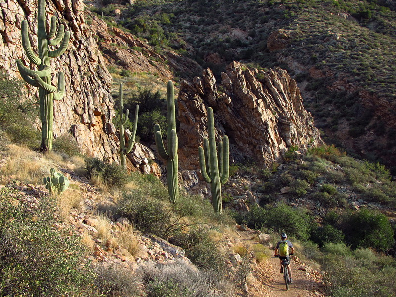
Some more AZ Trail singletrack for all you singletrack lovers out there! 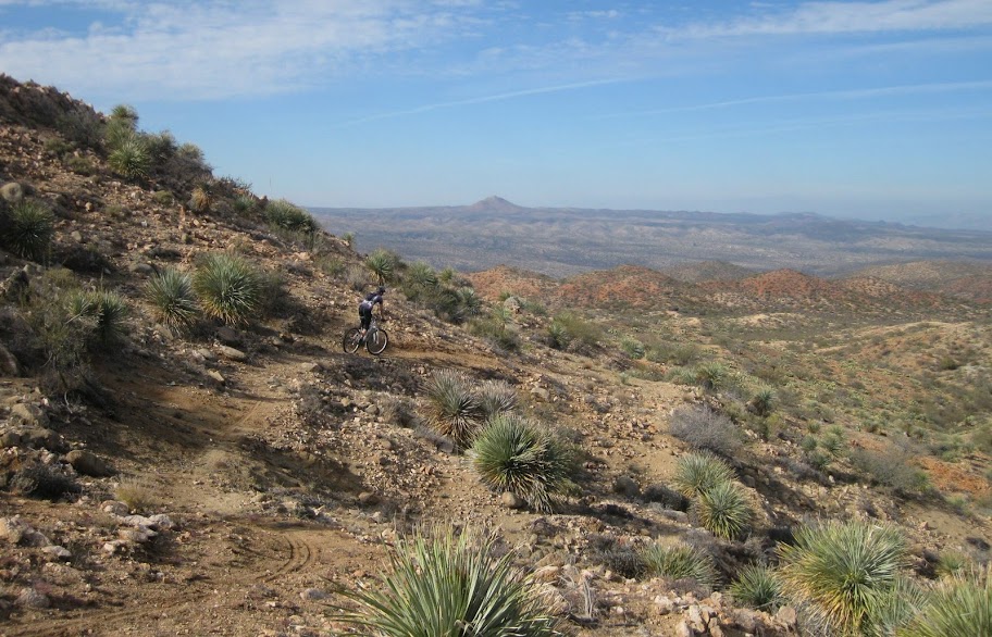 Antelope Peak in the back middle Scott and I rode a new section north of Oracle that now cuts off Bloodsucker and the Gasline (as already mentioned by Scott). Great ridge they choose to take; great views also! It seems as though you might want to add at least an hour to your Oracle-Superior time based on this new singletrack. 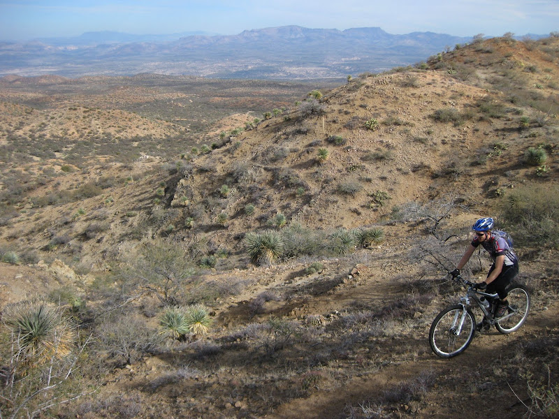 |
|
|
|
« Last Edit: December 12, 2011, 05:16:40 PM by Chad B »
|
Logged
|
|
|
|
|
Topic Name: 2012 AZT 300/750
|
Reply #66 on: December 12, 2011, 05:52:50 PM
|
tanman1337
Location: Yuma, AZ
Posts: 309
|
|
« Reply #66 on: December 12, 2011, 05:52:50 PM » |
|
I'm really really excited about riding the AZT this year, but I'm a little worried. You guys seem like you REALLY know every rock and turn of the whole 300... As long as I get the GPS file before the race is it going to be pretty easy to navigate? Thanks guys
-Tanner
|
|
|
|
|
Logged
|
|
|
|
|
Topic Name: 2012 AZT 300/750
|
Reply #67 on: December 13, 2011, 03:58:19 AM
|
AZTtripper
Moderator
Location: Tucson, AZ
Posts: 1732
|
|
« Reply #67 on: December 13, 2011, 03:58:19 AM » |
|
Tanner
With the track loaded and a copy of the cue sheets you should be fine for the most part.
There used to be a spot north of Patagonia that everybody missed, even those who had been there before. That's out now that we are on the east side of the Santa Rita Mountains.
Just make sure you keep an eye on the Gps and you'll do fine.
|
|
|
|
|
Logged
|
|
|
|
|
Topic Name: 2012 AZT 300/750
|
Reply #68 on: December 13, 2011, 04:06:40 AM
|
tanman1337
Location: Yuma, AZ
Posts: 309
|
|
« Reply #68 on: December 13, 2011, 04:06:40 AM » |
|
Cool Thanks! I was gonna hit up a little bit of the AZT over my break this XMAS. Any specific portion you recommend?
|
|
|
|
|
Logged
|
|
|
|
|
Topic Name: 2012 AZT 300/750
|
Reply #69 on: December 13, 2011, 05:01:17 AM
|
AZTtripper
Moderator
Location: Tucson, AZ
Posts: 1732
|
|
« Reply #69 on: December 13, 2011, 05:01:17 AM » |
|
Cool Thanks! I was gonna hit up a little bit of the AZT over my break this XMAS. Any specific portion you recommend?
Might not be a bad idea to ride the Canelo Hills, Parker Lake to Patagonia. That's the first 30 miles. There are a few immigrant trails down there so take a GPS with the track. That would be a good section to preview so you can make better time at the start. There is a water source at Cott Tank about 4 miles west of Canelo Pass. There is always water there but the last few years the spigot has been working. It's best to do the east Canelo Passage as a loop you could park/camp at Canelo Pass and ride back to the highway and down to Parker Lake. For the west passage the out and back isn't too bad and the loop back on the road is long. |
|
|
|
|
Logged
|
|
|
|
|
Topic Name: 2012 AZT 300/750
|
Reply #70 on: December 14, 2011, 02:04:18 PM
|
Chad B
Moderator
Posts: 484
|
|
« Reply #70 on: December 14, 2011, 02:04:18 PM » |
|
Cool Thanks! I was gonna hit up a little bit of the AZT over my break this XMAS. Any specific portion you recommend?
Ride the segment from Oracle to the Gila. |
|
|
|
|
Logged
|
|
|
|
|
Topic Name: 2012 AZT 300/750
|
Reply #71 on: December 14, 2011, 03:12:16 PM
|
tanman1337
Location: Yuma, AZ
Posts: 309
|
|
« Reply #71 on: December 14, 2011, 03:12:16 PM » |
|
Cool thanks guys. Do any of you have an "electronic" copy of a map with the whole 300 route with the different names you guys always use on it? Or is it just a gps file?
|
|
|
|
|
Logged
|
|
|
|
|
Topic Name: 2012 AZT 300/750
|
Reply #72 on: December 14, 2011, 06:48:52 PM
|
ScottM
bikepacking.net admin
Location: Wherever my rig is parked.
Posts: 2864
|
|
« Reply #72 on: December 14, 2011, 06:48:52 PM » |
|
GPS file + check out the cues to get a sense of the landmarks/names. Should be fairly clear if you are looking at a topo map w/ the GPS line, and have the cues too.
That said... cues and GPS need revision for the two biggest new chunks of singletrack mentioned here. We can hook you up with the GPS, but cues will take a little more time.
|
|
|
|
|
Logged
|
|
|
|
|
Topic Name: 2012 AZT 300/750
|
Reply #73 on: December 14, 2011, 06:58:01 PM
|
tanman1337
Location: Yuma, AZ
Posts: 309
|
|
« Reply #73 on: December 14, 2011, 06:58:01 PM » |
|
Ok cool! Well thanks for all your help.
|
|
|
|
|
Logged
|
|
|
|
|
Topic Name: 2012 AZT 300/750
|
Reply #74 on: December 15, 2011, 03:19:40 PM
|
LyndaW
Posts: 124
|
|
« Reply #74 on: December 15, 2011, 03:19:40 PM » |
|
As long as I get the GPS file before the race is it going to be pretty easy to navigate? Thanks guys
-Tanner
Scott's GPX track for the race is so tight that if you fall over sideways you are off route. The harder part is keeping your eyes on your GPS! Lynda |
|
|
|
|
Logged
|
|
|
|
|
Topic Name: 2012 AZT 300/750
|
Reply #75 on: December 17, 2011, 11:25:06 AM
|
rfutah
Location: Herriman, Utah
Posts: 31
|
|
« Reply #75 on: December 17, 2011, 11:25:06 AM » |
|
Heading down to Phoenix from SLC for two weeks on monday. Will be scouting this route to see if this is doable for me this year. Anyone got a good location to pick up maps to back up my gpx files? Thanks for any assistance. Will also be scouting water/food resupply (if anyone has that info) -Robert
|
|
|
|
|
Logged
|
|
|
|
|
Topic Name: 2012 AZT 300/750
|
Reply #76 on: December 18, 2011, 04:05:14 AM
|
AZTtripper
Moderator
Location: Tucson, AZ
Posts: 1732
|
|
« Reply #76 on: December 18, 2011, 04:05:14 AM » |
|
It's a great time to be here, we've been getting some rain and snow up high but otherwise it's perfect riding weather for most of the course. Not sure if there are any maps that show the actual AZT. some of the pics on this page are of trail that is less then 3 months old. One map I would recommend to anyone coming in from out of state. The AZ Atlas and Gazetteer maps http://www.barnesandnoble.com/p/delorme-240002-arizona-atlas-and-gazetteer-delorme/1107658174 These can be picked up locally at Summit Hut, Tucson Map and Flag, and most likely SorryEI. Price has gone up some seems like I got my last one for $10. Take the book to Kinko's ect and make copies of the pages the apply. Not so much for use on the trail but as a way to navigate yourself to trail heads and other off course options. |
|
|
|
|
Logged
|
|
|
|
|
Topic Name: 2012 AZT 300/750
|
Reply #77 on: December 18, 2011, 12:13:44 PM
|
rfutah
Location: Herriman, Utah
Posts: 31
|
|
« Reply #77 on: December 18, 2011, 12:13:44 PM » |
|
Thanks, I generaly use the Benchmark atlas. I think I might have a DeLorme, but it might be about 10 years old. I'll be checking with any BLM/FS offices I can find as well. Thanks again.
|
|
|
|
|
Logged
|
|
|
|
|
Topic Name: 2012 AZT 300/750
|
Reply #78 on: December 19, 2011, 09:25:47 AM
|
ScottM
bikepacking.net admin
Location: Wherever my rig is parked.
Posts: 2864
|
|
« Reply #78 on: December 19, 2011, 09:25:47 AM » |
|
The AZT 300 now has its own training plan! Created by last year's overall winner and super coach Lynda Wallenfels, the plan is packed not only with workouts and a training schedule but also packing, fueling, and strategy tips. I can think of no other single piece of gear, device or information that could increase your odds of finishing (or smoking) the route more than this plan. Check it out, here is the announcement: http://lwcoaching.com/?p=1476 |
|
|
|
|
Logged
|
|
|
|
|
Topic Name: 2012 AZT 300/750
|
Reply #79 on: December 20, 2011, 12:55:37 PM
|
|
|
|


