Topic Name: Dixie 311 Topic Name: Dixie 311
|
Reply #40 on: June 11, 2010, 11:28:48 AM
|
Chad B
Moderator
Posts: 484

|
 |
« Reply #40 on: June 11, 2010, 11:28:48 AM » |
|
Personal emails, up to date beta, SPOTs, post-ride massage...this race is legit. Looking forward to seeing the route and above all, riding with some fellow bikepackers.
Thank you again for putting this great event on!
|
|
|
|
|
 Logged
|
|
|
|
|
Topic Name: Dixie 311
|
Reply #41 on: June 14, 2010, 07:50:28 PM
|
GrizzlyAdam
Posts: 101

|
|
« Reply #41 on: June 14, 2010, 07:50:28 PM » |
|
You are an animal Dave. And you're making the homework for this one easy. Which is... eliminating my built-in excuses.
|
|
|
|
|
Logged
|
|
|
|
|
Topic Name: Dixie 311
|
Reply #42 on: June 20, 2010, 04:58:46 PM
|
Lee Blackwell
Location: Tubac, Arizona Leadville, Colorado
Posts: 28
|
|
« Reply #42 on: June 20, 2010, 04:58:46 PM » |
|
Hi 2 epic Lynda and Dave, The work you have done to help racers and bike tourists to enjoy this route is just stellar! Mike and I starting a tour on race day. Planning a 7 day schedule to allow time for enjoying the country. The route is absolutely enticing, drawing me like a magnet.  Lee B. |
|
|
|
|
Logged
|
|
|
|
|
Topic Name: Dixie 311
|
Reply #43 on: June 21, 2010, 07:57:55 AM
|
DaveH
Moderator
Posts: 975
|
|
« Reply #43 on: June 21, 2010, 07:57:55 AM » |
|
Thanks Lee! A 7 day plan will be perfect. It would be a sin to ride any of this route at night anyway. So much to see out there...
See you Saturday (if not sooner?).
|
|
|
|
|
Logged
|
|
|
|
|
Topic Name: Dixie 311
|
Reply #44 on: June 21, 2010, 10:34:57 AM
|
jonesy792
Location: Tucson AZ
Posts: 201
|
|
« Reply #44 on: June 21, 2010, 10:34:57 AM » |
|
Hey dave, is there any more info forthcoming on the dixie-lite? I'd love to do the 311 but I'm not sure that I can find the time for it
Jonesy
|
|
|
|
|
Logged
|
|
|
|
|
Topic Name: Dixie 311
|
Reply #45 on: June 21, 2010, 11:07:31 AM
|
DaveH
Moderator
Posts: 975
|
|
« Reply #45 on: June 21, 2010, 11:07:31 AM » |
|
Lot's coming shortly... Essentially you need a GPX file. I'm working on that right now, should be ready later today or early tomorrow. The region of the Dixie's received ~170% of usual snow this past winter, and until lately it's been a cool spring. The upshot of that is there is still too much snow above 10,500'. The original route hit 10,900 early and late. I was hoping it would melt out in time but after the past weekend's scouting mission it's apparent those segments are a no-go for this year's edition. I've known this could end up being an issue all along, otherwise I'd have released final GPX files. We (as in Lynda and myself) have cooked up a solution that includes more singletrack, good parking, and is essentially such a sweet change that it may stick permanently. The original route for the Dixie Lite can be viewed here: http://2-epic.com/maps/311map.html?map=dixie-lite.kml&index=1 The revised, (mostly) snow free version will see a completely different final segment, and a much changed first segment. Are there other questions that aren't covered on the website or this thread? Lynda will be riding the Dixie Lite, I'll be riding the 311. Here is what prompted the route change, about 10-15' of snow at 10,550'. While we could slog our way through it, I think postholing in deep melting snow at the tail end of a big enduro effort sucks. 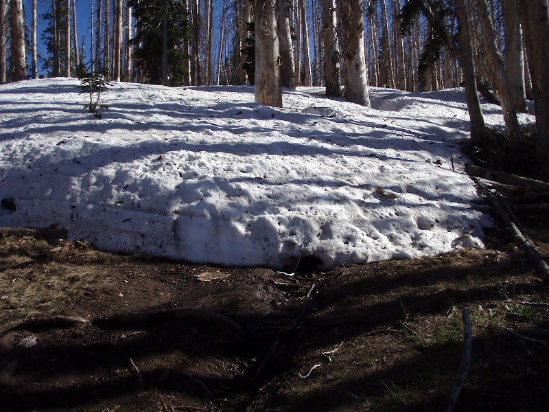 |
|
|
|
|
Logged
|
|
|
|
|
Topic Name: Dixie 311
|
Reply #46 on: June 21, 2010, 11:29:57 AM
|
DaveH
Moderator
Posts: 975
|
|
« Reply #46 on: June 21, 2010, 11:29:57 AM » |
|
I should mention that I've had quite a few questions about "which one to do", the 311 or the lite. I am recommending the Dixie Lite to anyone who is new to multi-day self-supported racing - in fact, that is exactly why I created this route. The "lite" is a bit of a misnomer because it isn't easy or short. It does have a minimal amount of hike a bike and good resupply options, covers lots of awesome trail, and is going to take at least 28 hours if you are out to bleed and 3 days if fast touring is more the goal pace. The 311, OTOH, is going to be tough. In the priority matrix of route developer, my #1 goal is to get to remote and beautiful places. #2 is get there by way of engaging, rideable terrain. Sometimes #1 overrides #2  What does that mean? If you have to hike your bike for very long, then there is either some very fun trail coming up or a breathtaking view - or both. Resupply is also not as good on the 311. Much better than Grand Loop tho  I will be really surprised if anyone pulls off the 311 in under 3.5 days, and I am planning for 4+. But, that's just a WAG (and a challenge to Chad!). I spent the last 3 days bikepacking dialing in the highest elevations of the route. My stoke for the route is off the charts! The weekend's pics are here: http://picasaweb.google.com/lh/albumMap?uname=hairball.dh&aid=5485254204104100929#map - all are geotagged thanks to PhotoFusion (part of TopoFusion).  |
|
|
|
|
Logged
|
|
|
|
|
Topic Name: Dixie 311
|
Reply #47 on: June 21, 2010, 02:35:42 PM
|
dkirk
Location: Yakima Washington
Posts: 55
|
|
« Reply #47 on: June 21, 2010, 02:35:42 PM » |
|
Nice photos Dave. I didn't want to look, for the surprise factor, but couldn't help myself.  |
|
|
|
|
Logged
|
|
|
|
|
Topic Name: Dixie 311
|
Reply #48 on: June 21, 2010, 02:50:03 PM
|
Done
Posts: 1434
|
|
« Reply #48 on: June 21, 2010, 02:50:03 PM » |
|
Wow, some beautiful places. Looks like an incredible ride. I wish that I had more time--I'd head out and give the "lite" version a go. Nice work, Dave. I'm eager to follow along via Trackleaders.
|
|
|
|
|
Logged
|
"Done"
|
|
|
|
Topic Name: Dixie 311
|
Reply #49 on: June 21, 2010, 04:14:54 PM
|
jonesy792
Location: Tucson AZ
Posts: 201
|
|
« Reply #49 on: June 21, 2010, 04:14:54 PM » |
|
sweet, count me in for a dixie lite run! I'll be doing a friday start though as I need to be back in tucson on monday
|
|
|
|
|
Logged
|
|
|
|
|
Topic Name: Dixie 311
|
Reply #50 on: June 22, 2010, 09:42:01 AM
|
DaveH
Moderator
Posts: 975
|
|
« Reply #50 on: June 22, 2010, 09:42:01 AM » |
|
The GPX route files are posted for the 311 and the D-lite, head on over to http://2-epic.com/events/latest.php for the beta. A long weekend of bikepacking has prompted some bigger than expected route changes, including a new start/finish location. It's surprising how well the changes fit though, now we'll be doing the entire Virgin River Rim trail and don't have a paved prologue. I’m still working on the waypoints – coming soon. There is lots of parking at the new start location of Woods Ranch. We can park there for the event, but be sure to park away from the pavilion area. There will be several events utilizing the area while we are out riding. Final route stats Start: Woods Ranch http://www.ironcounty.net/departments/parks_rec/woodsranch.cfm, 8AM Saturday June 26 for both distances. Dixie Lite 168 miles 24,046’ vert Dixie 311 314 miles 52,716’ vert The weather outlook couldn’t be better. Color me excited! |
|
|
|
|
Logged
|
|
|
|
|
Topic Name: Dixie 311
|
Reply #51 on: June 22, 2010, 09:52:34 AM
|
GrizzlyAdam
Posts: 101
|
|
« Reply #51 on: June 22, 2010, 09:52:34 AM » |
|
I can't focus at work. Well, I mean, I can't focus on work, at work.
|
|
|
|
|
Logged
|
|
|
|
|
Topic Name: Dixie 311
|
Reply #52 on: June 22, 2010, 11:20:51 AM
|
jonesy792
Location: Tucson AZ
Posts: 201
|
|
« Reply #52 on: June 22, 2010, 11:20:51 AM » |
|
Can't wait!  I only wish I had the time to do the 311  |
|
|
|
|
Logged
|
|
|
|
|
Topic Name: Dixie 311
|
Reply #53 on: June 23, 2010, 07:03:45 AM
|
DaveH
Moderator
Posts: 975
|
|
« Reply #53 on: June 23, 2010, 07:03:45 AM » |
|
All route files, waypoints, and quite a few other resources are good to go. If you didn't get the email go here for the scoop: http://2-epic.com/events/latest.phpI put the geek to bed late last night and what do you know, the bikepacker woke up early! |
|
|
|
|
Logged
|
|
|
|
|
Topic Name: Dixie 311
|
Reply #54 on: June 23, 2010, 08:24:08 AM
|
Chad B
Moderator
Posts: 484
|
|
« Reply #54 on: June 23, 2010, 08:24:08 AM » |
|
Dixie 311
314 miles
52,716’ vert
Anyway to add more climbing to the Dixie? Wow, this really is a beast. Looking forward to seeing how our legs react when we start up one of those climbs to near 11k. |
|
|
|
« Last Edit: June 23, 2010, 08:42:11 AM by Chad B »
|
Logged
|
|
|
|
|
Topic Name: Dixie 311
|
Reply #55 on: June 24, 2010, 01:39:28 PM
|
LyndaW
Posts: 124
|
|
« Reply #55 on: June 24, 2010, 01:39:28 PM » |
|
We have permission from Iron County Parks to leave our vehicles at the start location, Woods Ranch, during the race but there is no overnight camping there. They were pointed about the no ON camping! Sleep in the trees not your car ;-)
Also, Utah DOT just dumped 1000 or so tons of chips in the parking lot. There is still plenty space for us to park but we are asked to stay away from the pile of chips as 10 wheeler dump trucks will be scooping and spreading it on Hwy 14 next week. You really don't want you car in the way of that business!
LW
|
|
|
|
|
Logged
|
|
|
|
|
Topic Name: Dixie 311
|
Reply #56 on: June 24, 2010, 02:19:41 PM
|
GrizzlyAdam
Posts: 101
|
|
« Reply #56 on: June 24, 2010, 02:19:41 PM » |
|
I'll be in Cedar City Friday night. Anyone else? Probably going to car camp as close to the TH as I can.
|
|
|
|
|
Logged
|
|
|
|
|
Topic Name: Dixie 311
|
Reply #57 on: June 24, 2010, 02:32:03 PM
|
DaveH
Moderator
Posts: 975
|
|
« Reply #57 on: June 24, 2010, 02:32:03 PM » |
|
Deer Haven CG is just before the top of the hill beyond Woods Ranch. I believe the sign says "Webster Flat", its on the right maybe 3-4 miles up. You could camp there or in the million acres of surrounding forest...it's also right at the trailhead for the Virgin River Rim trail. So you'd drive back down to the start then ride back up |
|
|
|
|
Logged
|
|
|
|
|
Topic Name: Dixie 311
|
Reply #58 on: June 25, 2010, 06:07:38 AM
|
jonesy792
Location: Tucson AZ
Posts: 201
|
|
« Reply #58 on: June 25, 2010, 06:07:38 AM » |
|
Leaving vegas now, should be starting before 10
|
|
|
|
|
Logged
|
|
|
|
|
Topic Name: Dixie 311
|
Reply #59 on: June 25, 2010, 07:18:26 AM
|
dkirk
Location: Yakima Washington
Posts: 55
|
|
« Reply #59 on: June 25, 2010, 07:18:26 AM » |
|
Alternator replacement in Nephi, good times. I guess it's better than hitting a deer (TU). Just a little later start. Weather looks awsome!
|
|
|
|
|
Logged
|
|
|
|
|
|